1. Resolution
By now, we all know that DigitalGlobe is the only company to offer native 30 cm and 50 cm resolution imagery, and we have lots of it. DigitalGlobe has the most expansive commercial satellite imagery library and continues every day to collect more sub-meter resolution imagery than all other industry players combined. As illustrated below, there’s a significant advantage to the higher resolution DigitalGlobe offers in Basemap. More details are visible, but beyond that, you can derive more accurate results from analytical interpretation (human or machine), and realize better results when adding vector data or mapping.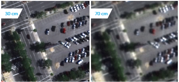 It is also worth noting that all imagery in the DigitalGlobe Basemap Suite is high resolution, from either native 30 cm or native 50 cm class sensors, whereas competing products may have high-resolution imagery over urban population centers but feature much lower resolution imagery over large rural areas, further reducing the quality and confidence in analysis and decisions derived from these products.
2. Deep historical and very recent time-lapse image browsing
DigitalGlobe Basemap is available in two main flavors. One of these features an advanced user interface for browsing images over time. This feature is useful for change-detection use cases, or for geospatial professionals who need to select an image from a specific timeframe from a large assortment. Basemap is a convenient, subscription-based way to access more than 1.5 billion square kilometers of DigitalGlobe imagery, the volume and quality of which is unrivaled by any other commercial provider.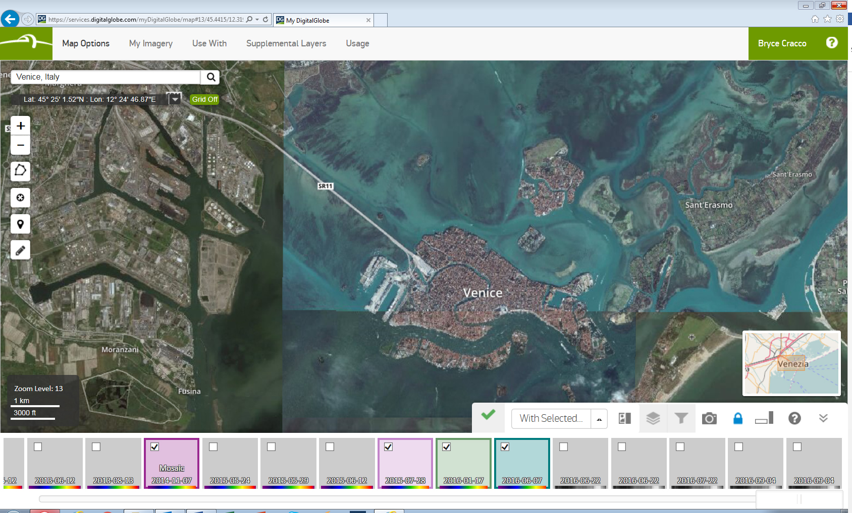 Further, DigitalGlobe Basemap automatically uploads ALL relevant new collections, and offers various filtering options for curation, cloud cover level, and other parameters. With Basemap, you can see only the clearest, high-quality imagery available, if that’s what you need. But if you need an image from the last few days to understand recent change, or even same-day imagery for emergency response purposes, and you are less concerned with curation and cloud cover, DigitalGlobe Basemap will show that set of images instead. Some competitors offer only curated imagery, or lack advanced filtering options, which dramatically reduces availability of recent imagery over many areas of interest. In this way, DigitalGlobe Basemap provides a unique level of flexibility and variety of options within the product suite to help you get the currency and inventory access you need at a price point that works for you.
3. Near- seamless, consistent mosaics
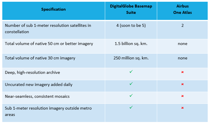
The second flavor of DigitalGlobe Basemap is near-seamless mosaic products. Other commercial offerings show a patchwork of manually curated imagery. By contrast, DigitalGlobe Basemap mosaic products are developed using a patented, sophisticated process that enables us to make mosaics at very large scale—even a country-wide scale—that appear as a nearly seamless and consistent single image. DigitalGlobe delivers a level of quality at scale that’s impossible using traditional manual curation methods. DigitalGlobe mosaics are processed at scale for geometric, radiometric, and seasonal factors, allowing imagery over large areas to be ready for immediate customer use with the best possible aesthetics and clarity, without additional imagery processing on the customer’s part. The differences are clear when you compare some key advantages of DigitalGlobe’s Basemap Suite to one of the newest entrants, Airbus’s One Atlas, as described on their September 29 webinar.
 To make the best products and technologies no matter your sector, start with the best raw materials. When you need the highest-quality geospatial imagery—whether you are a project-oriented geospatial professional, a software developer building an app, or a business manager—the DigitalGlobe Basemap Suite is the best, the only choice. Basemap is the most comprehensive, most capable, and highest-quality offering, and DigitalGlobe is invested in continually evolving it—expanded content, new features—to ensure our customers get the right information when they need it to make decisions with confidence.
Learn more about our DigitalGlobe Basemap Suite here.
To make the best products and technologies no matter your sector, start with the best raw materials. When you need the highest-quality geospatial imagery—whether you are a project-oriented geospatial professional, a software developer building an app, or a business manager—the DigitalGlobe Basemap Suite is the best, the only choice. Basemap is the most comprehensive, most capable, and highest-quality offering, and DigitalGlobe is invested in continually evolving it—expanded content, new features—to ensure our customers get the right information when they need it to make decisions with confidence.
Learn more about our DigitalGlobe Basemap Suite here.