Sentinel-2 Imagery
The Sentinel-2 constellation delivers imagery refresh over the entire globe every five days. Imagery is collected at a resolution of 10 m for visible and near infrared (VNIR) bands. [caption id="attachment_6187" align="aligncenter" width="922"] Sentinel-2 natural color image[/caption]
In addition to the VNIR bands, Sentinel-2 delivers 20 m resolution SWIR imagery. SWIR imagery detects light outside of the spectral bands that are visible to human eyes. For example, SWIR highlights areas that are very hot due to fires and volcanic eruption, and it also calls out differences in certain materials such as vegetation vs bare earth, and plastics versus concrete.
[caption id="attachment_6188" align="aligncenter" width="1015"]
Sentinel-2 natural color image[/caption]
In addition to the VNIR bands, Sentinel-2 delivers 20 m resolution SWIR imagery. SWIR imagery detects light outside of the spectral bands that are visible to human eyes. For example, SWIR highlights areas that are very hot due to fires and volcanic eruption, and it also calls out differences in certain materials such as vegetation vs bare earth, and plastics versus concrete.
[caption id="attachment_6188" align="aligncenter" width="1015"]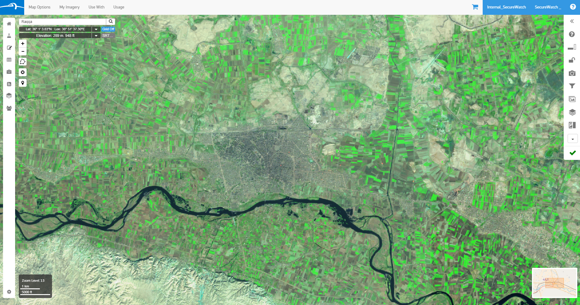 Sentinel-2 shortwave-infrared (SWIR) image[/caption]
Merging Mid- and High-Resolution Imagery in SecureWatch
SecureWatch delivers Sentinel-2 imagery using Open Geospatial Consortium (OGC) protocols via Sinergise’s Sentinel Hub. In the SecureWatch interface, users control visualization of Sentinel imagery, Google and OpenStreetMap basemaps, and high-resolution DigitalGlobe imagery. They can also mix the layers to enable quick cross-referencing. These are the Sentinel-2 layers are now available in SecureWatch:- Latest SWIR Image
- Latest Natural Color Image
- Latest Color Infrared Image
- Cloudless Natural Color Image
- Cloudless NDVI Vegetation Index
- Cloudless NDWI Water Index
DigitalGlobe Imagery + Sentinel-2 Imagery = Better Informed Analysts
Use Case 1: Investigating Areas of Interest in Raqqa, Syria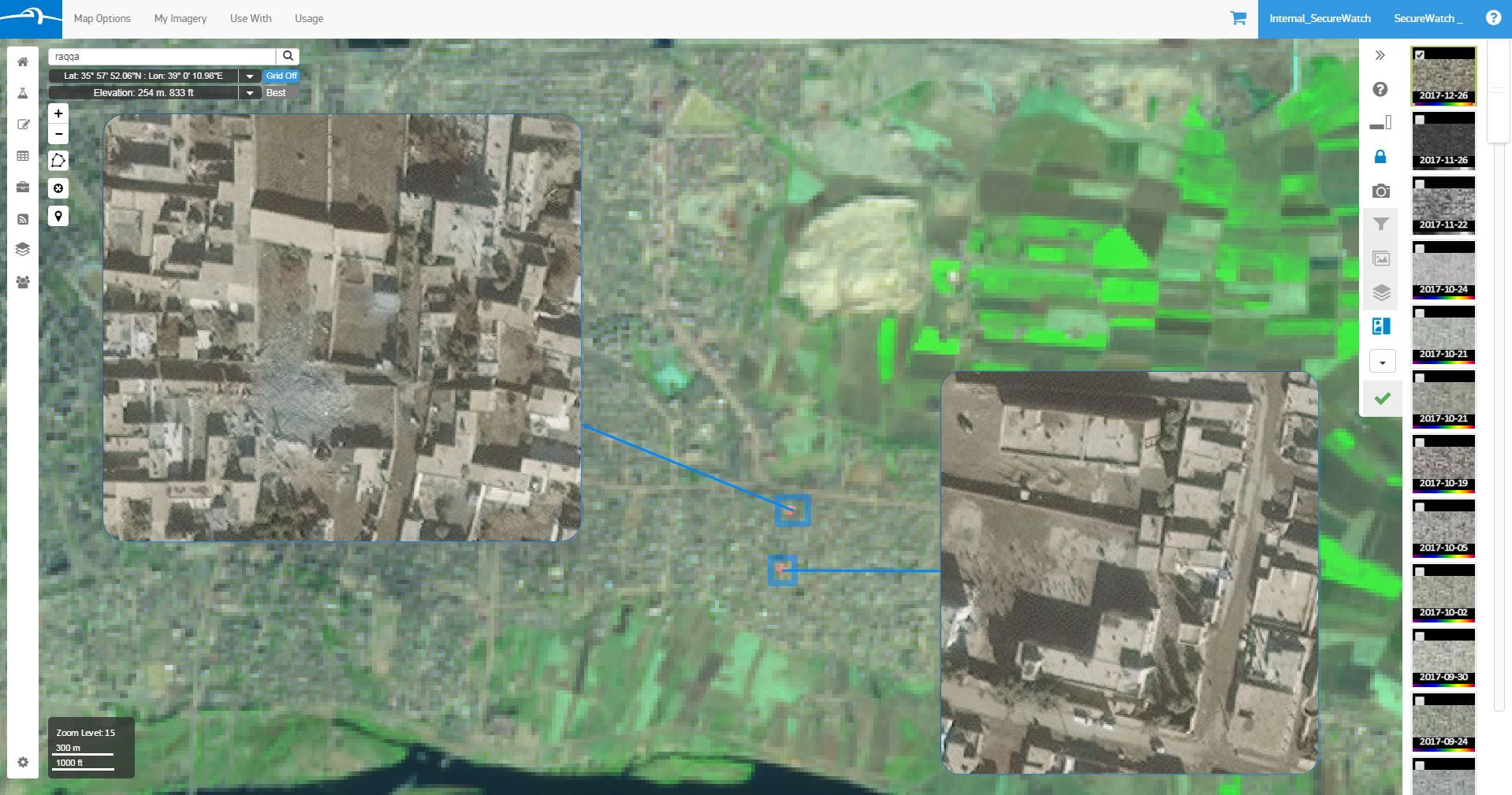 In the above Sentinel-2 SWIR image of Raqqa, Syria, two red dots appear in an image that’s mostly green. The red serves as an indicator that something is different from the surrounding area; in this case these two areas are emitting heat. At 20 m resolution, an analyst won’t be able to tell what’s changed on the ground. By bringing in the DigitalGlobe high-resolution imagery, the analyst will discover a destroyed mosque (left) and a school (right). The high-resolution insets are from a WorldView-2 image captured on December 26, 2017.
Use Case 2: Investigating New Construction in Latakia, Syria
In the above Sentinel-2 SWIR image of Raqqa, Syria, two red dots appear in an image that’s mostly green. The red serves as an indicator that something is different from the surrounding area; in this case these two areas are emitting heat. At 20 m resolution, an analyst won’t be able to tell what’s changed on the ground. By bringing in the DigitalGlobe high-resolution imagery, the analyst will discover a destroyed mosque (left) and a school (right). The high-resolution insets are from a WorldView-2 image captured on December 26, 2017.
Use Case 2: Investigating New Construction in Latakia, Syria
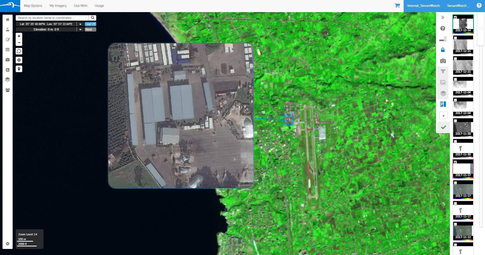 Using the above Sentinel-2 SWIR image of Latakia, Syria, an analyst catches changes in materials on the west side of the airfield. Once the analyst switches to the high-resolution DigitalGlobe image, they find newly constructed building roofs, which indicates significant military activity. The high-resolution inset is from a DigitalGlobe WorldView-2 image captured on December 14, 2017.
Use Case 3: Strategizing How to Extinguish the Southern California Wildfires
Using the above Sentinel-2 SWIR image of Latakia, Syria, an analyst catches changes in materials on the west side of the airfield. Once the analyst switches to the high-resolution DigitalGlobe image, they find newly constructed building roofs, which indicates significant military activity. The high-resolution inset is from a DigitalGlobe WorldView-2 image captured on December 14, 2017.
Use Case 3: Strategizing How to Extinguish the Southern California Wildfires
 An analyst monitoring a wildfire uses Sentinel-2 SWIR and DigitalGlobe imagery to monitor wildfires and firefighting progress using the images above:
- This Sentinel-2 SWIR image shows the Santa Rosa, CA wildfire on Oct. 10, 2017 in 20 m resolution. The burned part is brown and there’s a section of bright red (inside the yellow circle), which indicates this area is still hot and burning.
- Switching to DigitalGlobe’s WorldView-3 SWIR image at 7.5 m resolution, the highest resolution of SWIR imagery allowed to be commercially released by U.S. regulations, allows an analyst to further pinpoint the hotspot.
- The hotspot informs an analyst on where to request DigitalGlobe point its satellites to image the following day. This natural color image from Oct. 11, 2017 shows the area where the hotspot is located and what buildings have burned and still need to be protected.
- After the fire has moved away from the area, a follow-up image collection on December 1, 2017 indicates that firefighting efforts in this area succeeded at protecting buildings from being burned.
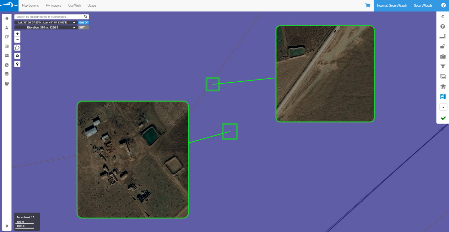 By visualizing the Sentinel-2 NDWI water index, an analyst is able to pinpoint standing water across large geographies. In the above example near the Iraq/Syria border, a high-resolution DigitalGlobe image from December 31, 2016 is used to determine if any human activity is occurring around two small water sources.