Land use data is critically important to the work of the California Department of Water Resources (DWR) and other state, regional and local agencies as they work to implement California’s first groundwater regulation, the Sustainable Groundwater Management Act (SGMA).
Understanding the impacts of land use, crop location, acreage and management practices on environmental attributes and resource management is an integral step in implementing the SGMA. SGMA calls for locally established Groundwater Sustainability Agencies (GSAs) in high- and medium-priority areas to reach sustainability within 20 years of establishing their Groundwater Sustainability Plans; this is an effort to bring groundwater basins into a balance of pumping and recharge. To meet these requirements and many others, a spatial mapping base layer is essential for reliable analysis and effective decision-making.
To develop this data, quality imagery at multiple points throughout the year is critical. Land IQ, an agricultural and environmental consultancy, integrates crop production knowledge with detailed ground truth information and multiple satellite and aerial imagery resources to conduct remote sensing land use analysis at the field scale. Maxar’s SecureWatch subscription service provides instant access to a library of images that Land IQ uses in its mapping process. To support SGMA implementation, Land IQ has developed a comprehensive and accurate spatial land use database for DWR, covering more than 14.2 million acres of agricultural, urban and managed wetlands.
Historically, this land use data had been collected through periodic field surveys that identified agricultural crops and other land uses within each county. However, with existing methods, these surveys were infeasible for statewide collections. As a result, there had been no publicly available comprehensive, current data resource for accurate field-scale land use statewide. Yet with the development of SGMA, DWR was required to provide datasets for local and state agencies for informed decision-making.

Land IQ’s field-level crop mapping is highly accurate, accounting for only the irrigated portion of the field, excluding buildings, roadways and other noncropped areas. Each color represents a different crop type.
In agriculture, some fields will produce multiple crops over the course of a year. DWR prefers to monitor water usage according to what’s called the “water year,” which is the 12-month period that starts on October 1. At Land IQ, the flexibility of the SecureWatch platform to filter imagery to particular dates (like the water year) and the frequency of available Maxar imagery help the database serve Land IQ’s needs.
To date, DWR has publicly released Land IQ mapping data for crop years of 2014, 2016 and 2018. This includes field-by-field classification of nearly 400,000 individually classified polygons with a minimum field size of 2 acres. The classification has been separated into approximately 40 crop categories that align with the DWR standard land use legend, with accuracies exceeding 96% for data released by Land IQ. In an era when land use drives water demand, every drop of water counts, and accurate land use is critical to determining water use.

This is an example of the dynamic nature of agriculture in California. Land IQ’s mapping demonstrates a single field in Monterey County, California, that had three crops of lettuce or leafy greens grown over the 2018 water year with peak production in April, June and September. Having the ability to filter Maxar imagery by date assists in this process.
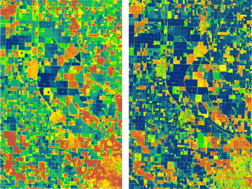
In addition to using Land IQ’s land use mapping for water-resource planning, local groundwater agencies are also tasked with tracking a water budget and accounting for water use by different water users. To assist GSAs with tracking agricultural water use, Land IQ performs field-level consumptive water use estimates utilizing a data-driven remote sensing approach. These estimates are based upon extensive ground truth measurements and multiple satellite imagery resources. By using Maxar’s high-resolution satellite imagery via a SecureWatch subscription, Land IQ’s derived results exhibit a high level of resolution and accuracy.

The two images above compare Land IQ’s field-level consumptive use results utilizing Landsat (left) and Maxar (right). Land IQ utilizes Maxar’s high-resolution satellite imagery for more detailed and accurate consumptive use results.
SecureWatch tools make Maxar’s satellite imagery more useful and accessible to the Land IQ team. Team members can easily access the data through Esri ArcGIS platforms, which integrate into existing workflows, from anywhere and on any device. Access to Maxar’s 20-year imagery library provides flexibility that Land IQ relies on to efficiently and accurately create products, which have great impacts on land and water management in the entire state of California on its path to sustainably using groundwater.
See how SecureWatch can help your organization. Request a custom demo today.