A large fire started at the port of Beirut, Lebanon on August 4, 2020, causing 2,750 metric tons of ammonium nitrate to explode and destroy a large swath of the city. The stockpile of common industrial chemicals, often used in fertilizer and as a component in mining explosives, created a blast equivalent of 1,000 to 1,500 tons of TNT. Move the slider back and forth to see the damage caused to the port.

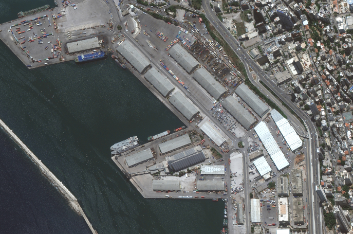
Maxar’s WorldView-3 satellite imaged Beirut’s port before and after the explosion.
According to the Lebanese Red Cross (LRC), 204 people were killed and at least 6,500 people were injured. With electricity out in most of the city, emergency workers were limited in what they could do. Immediately after the explosion, the LRC sprang into action bringing injured people to hospitals, facilitating blood transfusions, providing housing for people who lost their homes to the blast, finding missing family members and offering psychological support. Most of this immediate aid was carried out without a total understanding of the just how widespread the damage was. For high-level operational intelligence, the LRC turned to Maxar for help. By late afternoon the day after the explosion, Maxar captured more than 2,500 sq km of imagery over Beirut using our WorldView-1, WorldView-2 and WorldView-3 satellites, as well as activated our Open Data Program to provide the imagery under an open, non-commercial license to enable first responders to plan their actions.
“We received Maxar’s satellite imagery within 24 hours of requesting it, which made it possible to use the imagery for search and rescue efforts,” said Fabien Lezeau, GIS consultant for the Lebanese Red Cross. “We also used the imagery to conduct a damage assessment around the blast site. This imagery enabled the Lebanese Red Cross to more efficiently help the stunned residents of Beirut.”
During any humanitarian crisis, satellite imagery plays a crucial role in the proper allocation of resources to support people in distress. Non-profit organizations like the LRC need quick access to accurate information. When it comes to satellite access, latency refers to the amount of time that passes between tasking a satellite collection and receiving the resulting data. Most satellite imagery providers offer high latency access, meaning customers will have to wait up to a week after placing an order to receive usable imagery. Oftentimes, people in need can’t wait that long.
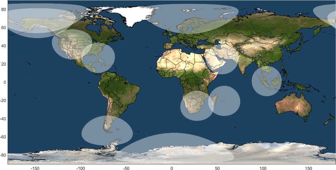
That is why Maxar delivers low latency imagery. Customers enrolled in our satellite access programs can update tasking plans up to fifteen minutes before an imaging event and receive data in real time after collection. These interactions with Maxar’s satellites are enabled by the company’s worldwide network of ground stations. The shaded areas in the map below represent our network’s communication cones with our satellites, which allow us to simultaneously downlink freshly collected imagery while uploading the latest collection plans.
Another reason that Maxar can deliver low latency imagery relates to the agility of our satellites. Our Collection Planning team utilizes our satellites ability to move quickly to capture as much imagery as possible–more than 3 million sq km of high-resolution imagery daily. This particularly comes in handy during a disaster scenario, like the Beirut explosion, where a satellite may not be directly overhead, but it can still look to the side and collect imagery that provides key insight into the situation on the ground. For example, check out these images that Maxar’s WorldView-3 captured after the Beirut explosion:

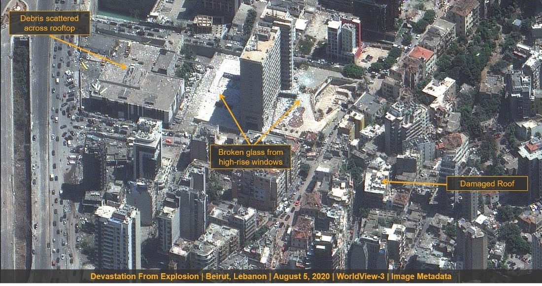
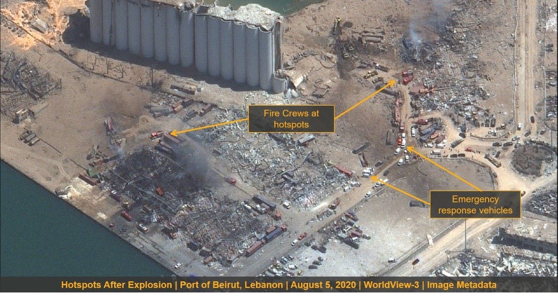
As the annotated images above show, these high off-nadir images still provide information that’s helpful for recovery efforts, like assessing damage to infrastructure and identifying fire hotspots. By giving the LRC, Lebanese government and other first responder organizations timely information and the ability to pinpoint exactly which homes have been damaged or destroyed and which areas require an immediate assistance, resources can be properly allocated to support the people most in need.
Learn more about Latency.