Updated: Please note that EarthWatch and SecureWatch have unified under the name SecureWatch, becoming Maxar’s premiere source for Earth intelligence access. Learn more about it here.
Introduction
At Maxar we face the continually evolving challenges of delivering very large amounts of data to our global mission partners, and also helping our partners unlock the insight inside that data. One aspect of the challenge is our high-resolution satellites collect over 80 terabytes of new imagery daily, adding to our 19-year, 100PB imagery library. And to further complicate the challenge, most use cases require that analysts access new images very quickly after collection to extract valuable insights, allowing leaders to make business and mission decisions with confidence.
Since we introduced SecureWatch for defense and intelligence mission partners and EarthWatch for commercial partners requiring location intelligence, we have tackled the continuous stream of data by developing technology that rapidly processes images and hosts highly compressed copies for full resolution browsing and rapid downloading via web services. This has proven a powerful and efficient way to deliver our product in a consumable way that’s easy for our partners to use. However, there are limitations to this approach, such as:
- We expend resources processing and storing a large number of pixels which are never used.
- High compression degrades the usability of images, especially for machine learning.
- Only the natural color (red, green, and blue) spectral bands are typically hosted while near infrared and short-wave infrared spectral bands have to be ordered.
- Dynamic range is adjusted during processing and cannot be adjusted afterward.
It’s all up in the cloud
As we transitioned SecureWatch and EarthWatch hosting to the Amazon Web Services (AWS) Cloud in 2018, we realized the opportunity to unlock the full power of all of our pixels. AWS provides virtually unlimited processing power via Amazon EC2 and unlimited storage via Amazon S3 – both products enable DigitalGlobe to store our complete and uncompressed image content in the cloud alongside our AWS-native Geospatial Big Data platform (called GBDX), which can process imagery on-the-fly. By leveraging this cloud-based structure, we’ve integrated GBDX into SecureWatch and EarthWatch, allowing partners to work in one interface.
We have introduced this new capability as Image Exploit Mode in SecureWatch and EarthWatch. Our first release enables users to:
- Preview and select images from our library that reaches back to 2000
- Choose from available spectral bands to reveal insights about activity on the ground
[caption id="" align="aligncenter" width="800"]

These SecureWatch screenshots show the new Image Exploit Mode with same WorldView-3 image of Punggye Ri, North Korea from October 8th, 2018. The visualization on the left is natural color (red, green, blue) and the visualization on the right is a false color composite that reveals additional insights into underground excavation by displaying the yellow, near-infrared, red edge spectral bands.[/caption]
[caption id="" align="aligncenter" width="800"]
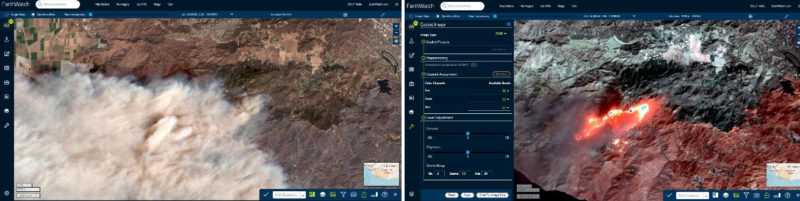
These EarthWatch screenshots show the same WorldView-3 image of the Thousand Oaks wildfire in California on November 11, 2018. The left image displays in natural color the fire’s smoke. The right screenshot demonstrates the power of Exploit Mode: by selecting to show SWIR bands S6, S3, and S1 on the same image, the viewer can see through the smoke.[/caption]
3. Adjust the dynamic range to optimize visualization for nearly any light condition
[caption id="" align="aligncenter" width="800"]
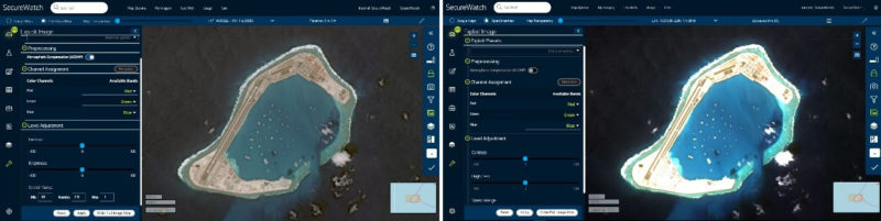
These SecureWatch screenshots show the new Image Exploit Mode with the same WorldView-4 image of Subi Reef. Lighting conditions are challenging for this image due to the dark blue of the ocean and bright white of the sand on the reef. The left image is optimized to identify objects in and around the bright white sand. The right image is optimized to identify objects in and around the dark blue water.[/caption]
4. Apply DigitalGlobe’s powerful Exploit mode, including Atmospheric Compensation (ACOMP) algorithm for cutting through haze and other atmospheric effects
[caption id="" align="aligncenter" width="800"]
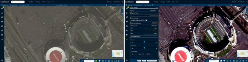
These EarthWatch screenshots show the same WorldView-3 image of the Oakland Coliseum. On the left, it’s a non-processed natural color image. The right side uses Exploit Mode to apply ACOMP, removing atmosphere particulates that make the image look hazy.[/caption]
How it works
To deliver immediate access to custom imagery production through Image Exploit Mode, DigitalGlobe needed to rethink our traditional image processing system. Traditional image processing dictates that massive systems produce entire scenes with set parameters, such as ortho-rectification and pan-sharpening, before an analyst requests the image.
The GBDX team developed Raster Data Access (RDA), which quickly processes images in the AWS cloud in real-time to the specifications the customer requests. RDA powers the new Exploit Mode available in SecureWatch and EarthWatch, allowing users to define exactly how they want to see imagery and deliver it to them quickly. So now, instead of receiving produced imagery created with pre-set standards, customers can choose the parameters they want for their specific use and receive it in real-time.

While it sounds more complicated to custom-produce each image instead of pre-producing all suitable imagery, RDA is truly simple in operation. Both RDA and the imagery that it accesses are “cloud native,” meaning all the parameters of the imagery are available for RDA to process: the full bandwidth of spectral content, dynamic range adjustment (DRA), and metadata that was captured by our satellite constellation. Therefore RDA is ready to provide results immediately no matter what level of processing the user needs. In addition, RDA provides benefits to users by allowing more flexible and faster access to data while allowing DigitalGlobe to store only raw data from which nearly any derivative can be created on-the-fly.
And so much more to come…
These new, on-the-fly image processing and visualization tools available in the latest release of SecureWatch and EarthWatch only start to scratch the surface of what can be done with the combined power of AWS, the DigitalGlobe image library, and our GBDX services. This new architecture has created opportunities for many capabilities which we are developing for future releases. Here are some of the new SecureWatch features we’re looking at developing:
- Publishing images from Exploit Mode to the Online Carousel and Download Library
- Enabling Image Exploit Mode for the massive Ikonos mission archive (1999 to 2015)
- Additional visualization tools such as image rotation, automatic DRA, and advanced image resampling at high zoom states
- Integrated machine learning processes to narrow search windows and alert users to detected activity
For defense and intelligence mission partners to learn more about SecureWatch and request a free 30-day evaluation, visit us here: https://www.digitalglobe.com/products/securewatch
For commercial sector partners to learn more about EarthWatch and request a free 30-day evaluation, visit us here: https://www.digitalglobe.com/products/earthwatch