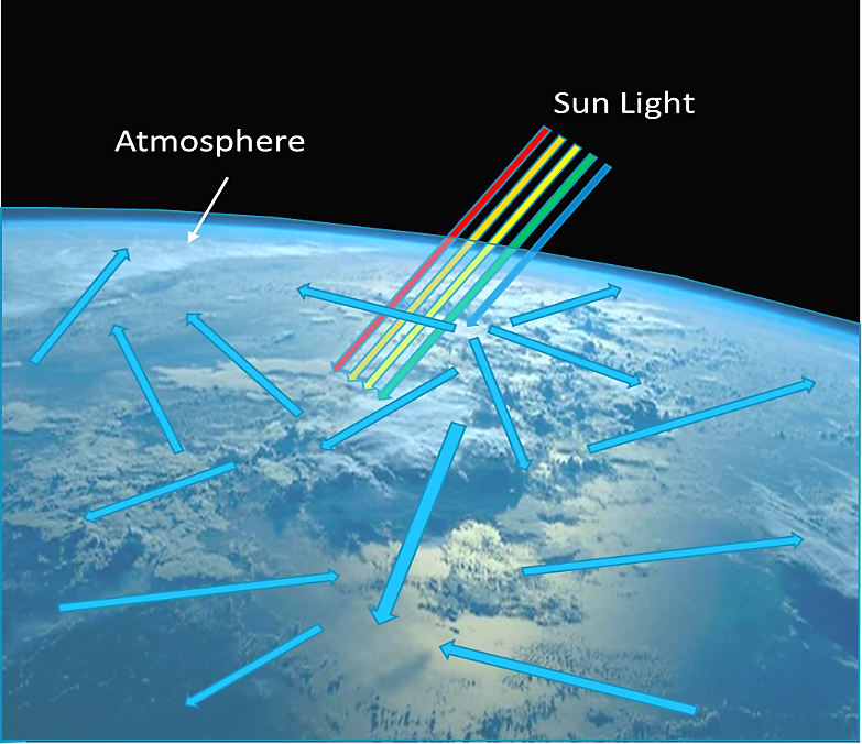
 How does this relate to satellite imaging and AComp? From the perspective of the Earth’s surface, our atmosphere is a protective shield—and we’re all thankful for it. But from a satellite’s perspective it’s a barrier to be crossed. When a satellite takes an image, the light reflecting from the ground is impacted by the atmosphere and can affect the visual aesthetics of the image. For example, place a straw in a glass of water and look at the straw from the side. The straw will appear to be bent or disjointed because the water, like the atmosphere, can bend, scatter or refract the light, and this affects what you see. AComp significantly improves image quality by adjusting for this atmospheric scattering across diverse conditions.
The mapping industry has used and developed various atmospheric compensation tools requiring high and low levels of expertise with varying outputs of quality. DigitalGlobe AComp is powered by our proprietary algorithm, which is unique in the industry. It promises real benefits to everyone who uses optical satellite data—from consumers of foundational images who will be able to solve real-world problems, to image scientists who need surface reflectance to have consistent spectral information to perform image analytics.
How does this relate to satellite imaging and AComp? From the perspective of the Earth’s surface, our atmosphere is a protective shield—and we’re all thankful for it. But from a satellite’s perspective it’s a barrier to be crossed. When a satellite takes an image, the light reflecting from the ground is impacted by the atmosphere and can affect the visual aesthetics of the image. For example, place a straw in a glass of water and look at the straw from the side. The straw will appear to be bent or disjointed because the water, like the atmosphere, can bend, scatter or refract the light, and this affects what you see. AComp significantly improves image quality by adjusting for this atmospheric scattering across diverse conditions.
The mapping industry has used and developed various atmospheric compensation tools requiring high and low levels of expertise with varying outputs of quality. DigitalGlobe AComp is powered by our proprietary algorithm, which is unique in the industry. It promises real benefits to everyone who uses optical satellite data—from consumers of foundational images who will be able to solve real-world problems, to image scientists who need surface reflectance to have consistent spectral information to perform image analytics.
Learn more about DigitalGlobe Atmospheric Compensation (AComp)
What are the benefits of AComp?
- More of our 16-plus year time-lapse archive of high-resolution imagery is unlocked
- Reduced collection failure rates due to haze
- Improved quality for imagery from new collection
- Enhanced customer experience with DigitalGlobe products