 If you are an imagery scientist you already know how valuable SWIR data is for satellite image interpretation. However, if you are new imagery user or a user that has only worked with color imagery you may not be familiar with the value SWIR can unlock. Let’s start with an example everyone can understand. Earlier this year there was a great viral debate over the color of a dress…Was it “blue and black” or “white and gold”? (Spoiler, it was blue and black). The debate sparked noteworthy comments from ordinary people “if that’s not gold my entire life has been a lie” and trained scientists “what’s happening here is your visual system is looking at this thing, and you’re trying to discount the chromatic bias of the daylight axis,” says Bevil Conway, a neuroscientist who studies color and vision at Wellesley College. Clearly people are amused and interested by these types of optical illusions. And what we see with our own eyes creates a very powerful sense of certainty in our interpretation of the word around us.
But what if these colors were in a satellite image and being used to make a decision that would save lives, resources or time? Would we accept such strong differences of opinion? No we would not. Would we want a higher level of certainty? Yes we would. Satellite images with near-infrared and shortwave infrared light waves can provide us with the higher levels of interpretability, certainty, and give us the answers we need to make better decisions.
WorldView-3 is the first commercial high-resolution satellite to provide eight spectral bands in the short wave infrared (SWIR) range, in addition to the eight in the visible and near infrared (VNIR). Each SWIR and VNIR band is narrowly focused on an area of the electromagnetic spectrum that is sensitive to a particular feature on the ground or a property of the atmosphere. Used together, these bands allow us to find, see, and interpret features in satellite imagery like never before.
What is Visible and Near Infrared (VNIR) Imagery?
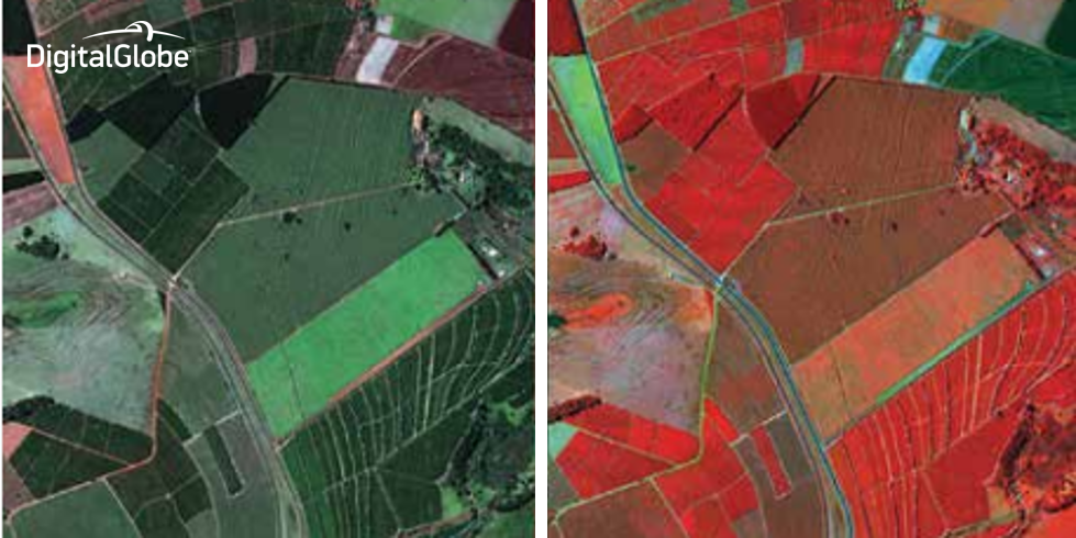
VNIR refers to visible light (the "V" in VNIR), which is the light we all can see with our eyes. Technically speaking these are light waves that fall between 390 and 700 nanometers (nm). Near infrared imagery (the "NIR" in VNIR) is just beyond the capabilities of our eyes and it represents the light waves that fall between 750 and 950 nanometers. Even though we can’t see these near infrared waves they behave just like visible light and reflect off objects all around us. For example, near infrared imagery is ideal for conducting vegetative analyses that can reveal plant type, age, health, and diversity in much greater detail than visible imagery alone. Four-band VNIR high-resolution satellite imagery has been available since the launch of IKONOS in 1999. Eight-band very-high-resolution VNIR satellite imagery is unique to WorldView-2 and WorldView-3. [caption id="attachment_4081" align="aligncenter" width="700"] Figure 1. WorldView-2 and WorldView-3 have eight visible and near infrared (VNIR) bands which are ideal for vegetative analysis and mapping. Visible imagery is shown on the left and near-infrared imagery is shown on the right. Note that healthy vegetation appears red and bare ground appears green in the near-infrared image.[/caption]
What is Shortwave Infrared (SWIR) Imagery?
SWIR refers to a non-visible range of light falling between about 1400 and 3000 nanometers in wavelength, outside of the visible range. Due to the unique properties of minerals, man-made material, and other features, SWIR imagery can “see” objects in a way that is invisible to the naked eye and VNIR sensors. [caption id="attachment_4085" align="aligncenter" width="750"] Figure 2. WorldView-3 has eight shortwave infrared (SWIR) bands in addition to eight visible and near infrared.[/caption]
Collecting satellite imagery in SWIR wavelengths has unique benefits, including improved atmospheric transparency and material identification. Many materials have specific reflectance and absorption features in the SWIR bands that allow them to be identified from space. Snow and ice, different rock types and man-made materials are distinct and can be differentiated in the SWIR bands. SWIR imagery can even penetrate some types of smoke, such as from a forest fire, and identify “hot spots."
[caption id="attachment_4088" align="aligncenter" width="750"]
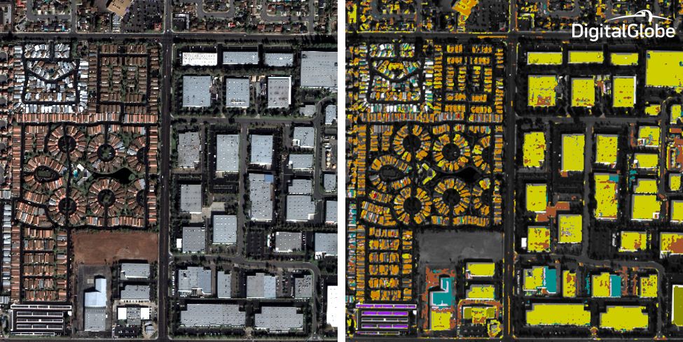
 Figure 3. WorldView-3 has eight shortwave infrared (SWIR) bands which are ideal for material identification and mapping. Visible imagery is shown on the left and classification using SWIR imagery is shown on the right. Note that different roof top materials that look the same in the visible imagery are clearly differentiated in the SWIR imagery.[/caption]
DigitalGlobe launched our SWIR Imagery product this week. We've been building SWIR coverage in our Image Library throughout 2015, and offer new collection for areas not yet covered with SWIR Imagery. Our 7.5-meter resolution product has 16 times more information than previous satellite SWIR sensors.
Contact DigitalGlobe or a DigitalGlobe partner to see if SWIR can help you solve your problems with higher levels of certainty.
Our next post in this series will explore some of the most impactful uses of SWIR Imagery.
Deke Young is Senior Director of Product Management at DigitalGlobe.