Identifying Man-Made Materials
Due to the unique way that man-made materials reflect light in the SWIR wavelength, it is possible to tell the difference between materials that look similar to the naked eye in the visible light spectrum. There are many reasons to understand the different types of man-made materials that are present in a particular area. In the images below an oil refinery in Algeria (shown in visible imagery on the left) imaged in SWIR reveals the materials used to construct it (center image) and that there are active flare stacks (right image). Other examples of using SWIR to accurately classify man-made materials include an urban planner who needs to know building roof types to plan for fire mitigation, a transportation/logistics manager who needs to know road types to plan for material deliveries to job sites, or an analyst who needs to understand materials being used in new construction to determine the purpose of the construction. SWIR can answer these questions with satellite data that has not been available until now.
Fighting Fires
Whether called a forest fire, bush fire, or wildfire, uncontrolled fires have a devastating impact on communities and natural resources. Fast and effective detection is key to protecting infrastructure and ensuring communities’ safety. While it seems that fires should be easy to see, there are often obstacles that get in the way. First, smoke obscures what the firefighters can see – both on the ground and from the air. Also, aerial imagery can see only the tops of trees and can give a false impression of how large a fire is on the ground. In the image below on the left, it is easy to see where the smoke is coming from, but can you pick out the ground fire along the fence line? The SWIR image on the right goes through the smoke and highlights the hot spots to show the firefighters which areas they needed to watch. In the images above SWIR was used to image an active wildfire outside of Adelaide, Australia. Visible imagery on the left clearly shows the extent of the smoke while the SWIR image on the right sees through the smoke and enables responders to accurately “see” the wildfire.
You can experience the utility of how SWIR can help spot wildfires by joining our Tomnod crowdsourcing campaign to identify illegal burning in Indonesia.
Minerals and Mining
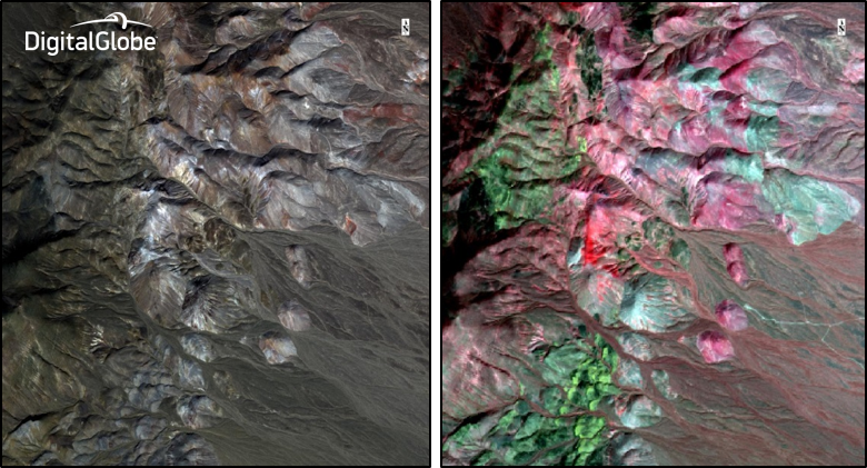
WorldView-3’s spectral bands allow for precise mineral identification and chemical measurements. Energy from light is either transferred to molecules of matter or reflected away from them. Based on the mineral content, different materials absorb specific wavelengths of light and reflect others. In the images below, visible imagery (left) shows a mining region but does not provide meaningful information about the geology and mineralogy. In the SWIR image (right) geology and mineralogy are clearly distinguishable and enables geologic interpretation. The SWIR imagery available from WorldView-3 was designed with geologic applications in mind. Electronic absorptions in the SWIR wavelengths can be used for detecting materials containing anion groups such as Al-OH, Mg-OH, Fe-OH, Si-OH, carbonates, ammonium, and sulphates - many of which are indicator minerals in the mining industry. Exposed outcrops are manifestations of potential mineral ores or sub-surface deposits. While the geology and mining industries spend millions of dollars to identify potential mining sites during their exploration phase, WorldView-3 SWIR data can cut costs and increase efficiency by narrowing the potential area before field verification is planned.
We’ve recorded several webinars this past year that go into much more detail about the many users of SWIR Imagery. Check out our webinar series to learn more.
Deke Young is Senior Director of Product Management at DigitalGlobe.