People often reference the idiom seeing is believing. And high-resolution satellite imagery technology has helped governments and commercial organizations visualize the planet in extraordinary ways. But, there's more to satellite imagery than what you can see. Accuracy is an important component that is often misunderstood.
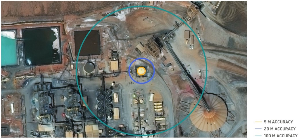
While a high-resolution image can help you see a building clearly, that doesn’t guarantee geolocation accuracy (or where the building actually sits on Earth’s surface). Accuracy specifications are measured by circular rate of error (CE). Maxar includes stated accuracy for every image, which guarantees a 5 m CE90—in other words, there is a 90% confidence rate that all measured points fall within a 5 meter radius (see below).
Stated accuracy specifications are critical for safety, compliance and cost-effective operations. Miscalculations in distance and geolocation can cause a myriad of problems from operational delays to hefty legal fines, yet many imagery providers don’t offer stated accuracy at scale (or at all).
As a pioneer and global leader in satellite imagery and derived geospatial data, Maxar knows how important accuracy is for our customers—especially for those operating in remote areas. Take oil and gas companies for example, identifying new well pad sites and ensuring drilling is the regulated distance from other infrastructure can become incredibly expensive with field visits for research, surveying, and eventually drilling and construction of assets.
Oil and gas companies often compile and consult multiple datasets from unreliable third-party sources. Consistency in multisource data is difficult. Some oil and gas well pads are as close as 20 feet from one another, so it’s key to have a solid understanding of where everything is located. Using Maxar satellite imagery as a foundation can help verify and conflate diverse data points for simplified analysis, enabling the end user to make confident decisions with high stated accuracy. Having data that can deliver geolocation accuracy at this level and at scale over remote regions offers oil and gas companies, among many other industries, unprecedented visibility and value into their remote operations.

For compliance and safety, companies need to know what is going on around their assets, the distance between structures, and even what’s happening underground (the white lines indicate horizontal drilling).
In development planning, asset monitoring and emergency response, geolocation accuracy is not a perk that can be ignored. Accurate imagery is the foundation for derived data such as digital elevation models and analysis, like encroachment. It can mitigate risks and expedite action in the event of a disaster, like flooding or infrastructure malfunctions, to minimize damage.

Odessa, Texas oil fields imaged by Maxar's WorldView-2 satellite on August 25, 2019.
Dig into the details about Maxar’s accuracy and how it can help your business reduce risks and resources.