Intelligence analysts monitor thousands of sites of strategic interest on a daily basis, using satellite imagery to spot potential threats or abnormal behaviors. When monitoring such a variety of locations, including military compounds, harbors, airfields and more, there is a risk of missing important signals due to the lack of bandwidth to interpret all the incoming data.
This is why Earthcube has automated the analysis process by pairing Maxar’s high-resolution satellite imagery and SecureWatch platform with artificial intelligence (AI), enabling 100 percent of the satellite imagery over the areas of interest to be processed, creating a tip-and-cue workflow to direct analysts to pay attention to sites where their tradecraft is actually needed.
From Maxar’s satellites to defense analysts
Despite a continuous increase in the number of satellites imaging the Earth, the number of analysts processing the resulting data does not follow the same trend. Hence the need to automate the time-consuming tasks using AI, thereby optimizing how analysts spend their time.
Maxar’s commercial satellite constellation (WorldView-1, WorldView-2, WorldView-3 and GeoEye-1) collects more than 70 terabytes of high-resolution images of the Earth daily. With this amount of incoming data for training and analysis, Earthcube’s algorithms achieve an exceptional object recognition level.
When the fresh imagery is available via SecureWatch, Earthcube uses a few API calls to pull the images into our site monitoring platform for processing. S-Cube, our cloud-based platform for strategic monitoring, runs our object-recognition algorithms on Maxar’s satellite imagery to detect and classify objects of military interest and highlight patterns. Results from the algorithms are available to analysts within minutes. These functions allow an analyst to follow developments at a specific site through time. To learn more about how Earthcube trains its algorithms on Maxar imagery, read this blog post.
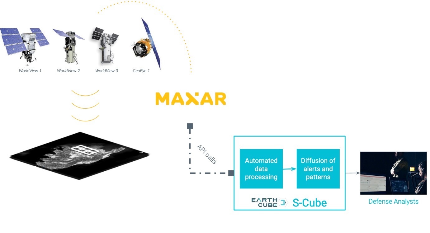
The strength of Maxar’s API enables a very fast integration, allowing any new monitoring site to be operational within days following a specific customer’s request. As soon as images of this new area are accessible on S-Cube, analysts can make their own primo-analysis — divide the site into sub-areas following NATO Stanag 3596 standards and define the criteria of alerts based on the analysts’ needs. From there, the automatic analysis is ready to run and results update themselves as soon as Maxar’s satellites capture fresh imagery of the site.
Examples of S-Cube’s results thanks to Maxar’s imagery
Taminhint Airport, Libya
The S-Cube graphs below show the aircraft activity evolution and do not indicate the presence of combat or transportation aircraft. These results indicate that Taminhint Airport does not seem to be an active site so an analyst should not spend hours monitoring it.
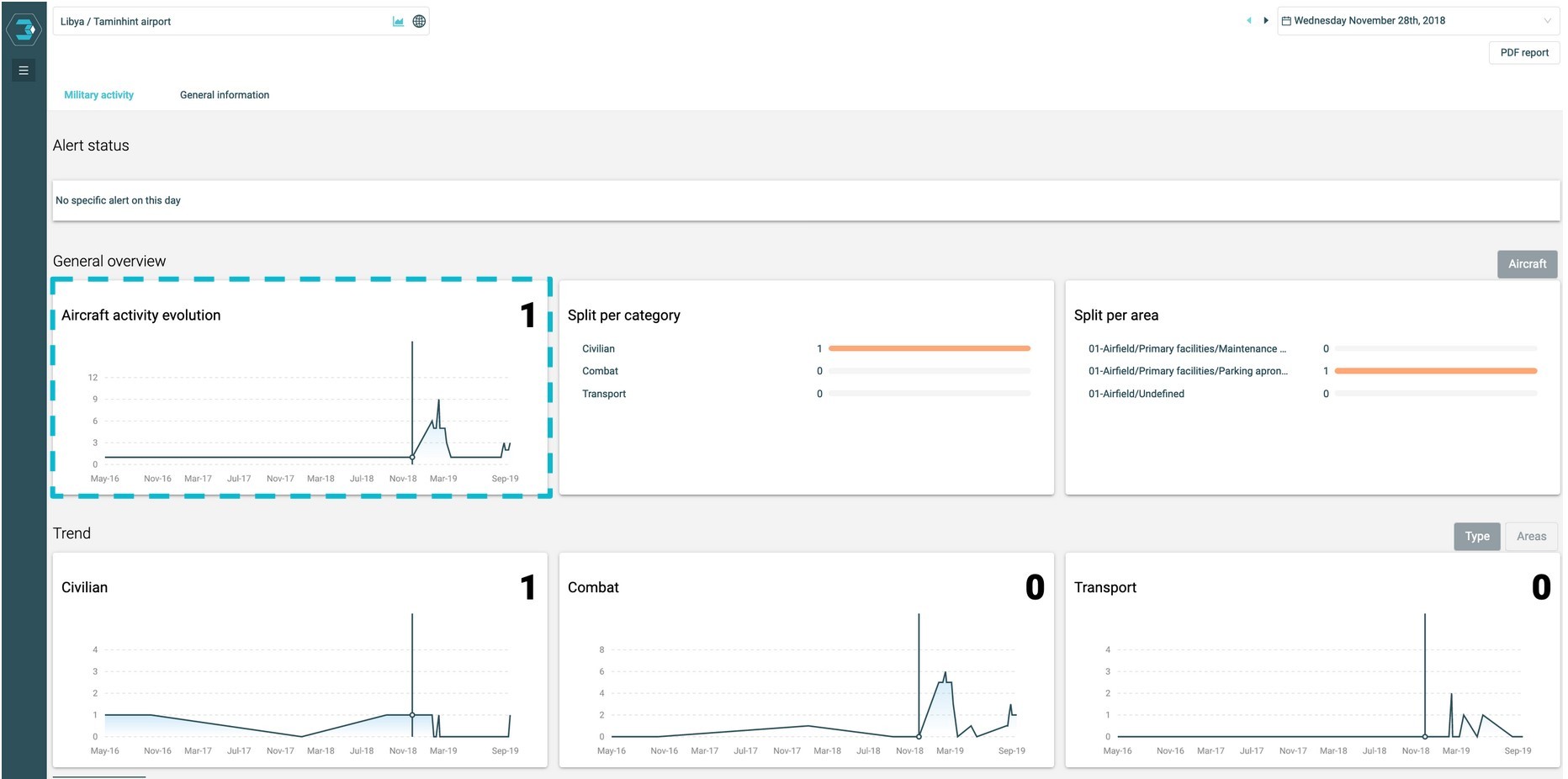
Although, some intriguing events are about to happen. The automatic alerts (below) highlight abnormal behaviors related to transport and combat aircraft in the parking zone.

By looking at the Maxar image streamed through SecureWatch’s API, it appears that a transport aircraft is either loading or unloading armored vehicles, and an analyst can clearly spot the presence of combat aircraft on the apron.
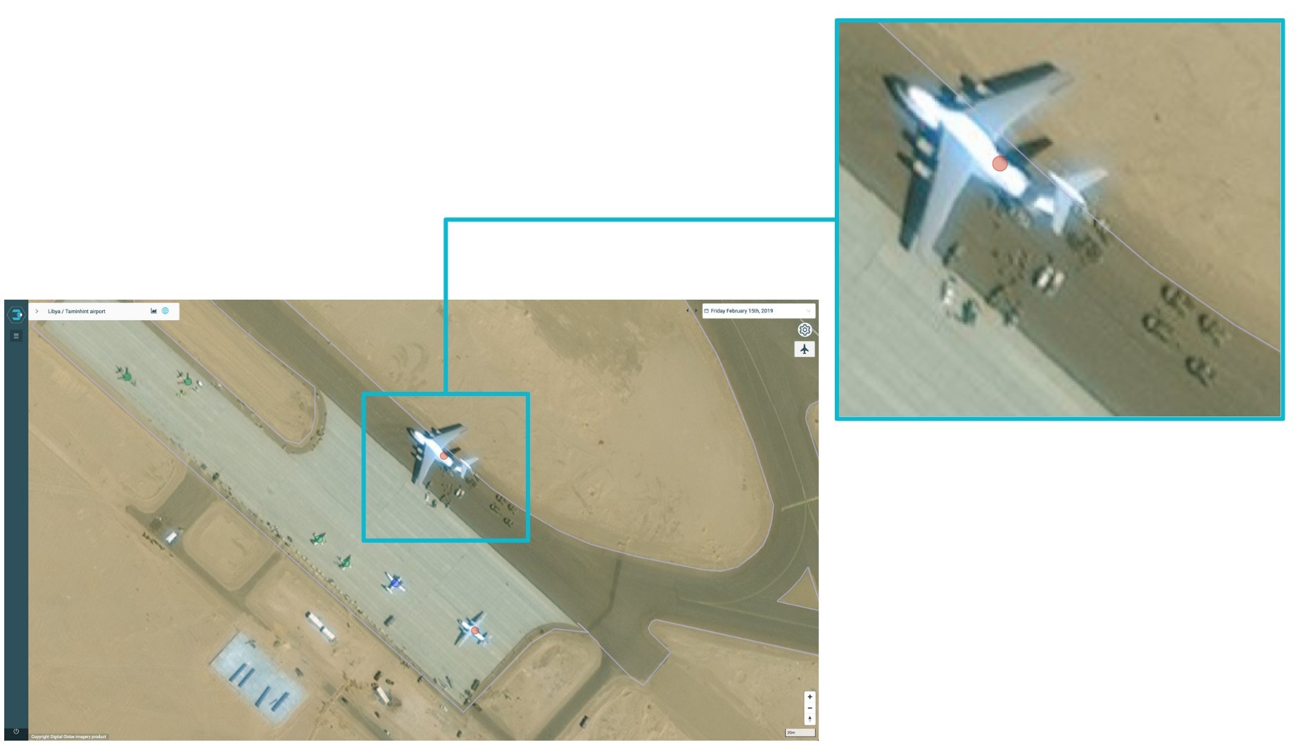
In this image, the red dots indicate the detection and classification of a transport plane by Earthcube’s algorithms, the green dots call out combat aircraft and blue dots identify civilian aircraft.
This is typically the type of behavior that analysts would be looking for. The alerts have brought attention to an aircraft that’s capable of bringing equipment, munitions and support to a nearby combat zone. This kind of alert allows the analyst to focus their time on places where changes are happening and insights can be gained.
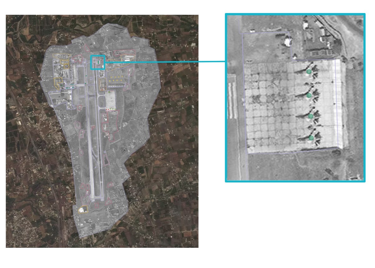
Hmeimim airport, Syria
Another detection can be found at the Hmeimim airport. In the Maxar satellite image below, one can clearly see combat aircraft, noted by AI with green dots in the image on the right. Digging into the previous positions of those Flankers aircraft, analysts will realize that this is the first time that the planes are stationed here. This highlights a change of posture regarding aerial defense, which is precious information for the analysts and provides insight into upcoming events.
Maxar’s features that keep our analytics updated
Earthcube’s site monitoring platform provides fast and reliable analysis to defense end users. Key features enable our analytics to provide precise identification and remain updated automatically:
- Maxar’s constellation offers frequent revisit at a pace that allows S-Cube to be an efficient monitoring solution, where alerts highlight events on a reasonable timeline for intervention.
- WorldView-3’s 30 cm resolution is critical for precise model identification. Beyond object recognition, the strength of our algorithms lies on their ability to classify the objects of interest. The algorithm can differentiate between 90 types of aircraft automatically on a Maxar satellite image, which is only possible using the highest resolution images commercially available.
- Access to Maxar’s 110-petabyte imagery archive that dates back to 2000 has proven key to putting new information into context. The number of fighter aircraft or submarines at a given date is one important piece of information, but being able to put it in context and compare that number to its evolution for the past months or years provides a whole new perspective on how to interpret what’s happening at the site of interest.
Combining these elements from Maxar with Earthcube’s AI allows S-Cube to provide a powerful solution for defense analysts to maximize their time and create the best insights available for decision makers.