 We recognized that historical information was at risk of being destroyed since it had been 40 years since Jeffrey Parsons and William Sanders conducted the foundational Basin of Mexico archaeological surveys. We were particularly concerned about the smaller sites—the settlements where the vast majority of people once lived. However, we had one major problem: we lacked the time and resources to physically visit the sites and assess their condition, as Parsons and Sanders (and their students) had done in the 1970s. We needed a regional methodology that was more practical.
We had two things going for us. First, archaeologists had recorded the coordinates of each of the archaeological sites they found as well as the land conditions (i.e., farming, pasture, etc.). Second, advancements in satellite remote sensing have made it much easier to acquire and process large amounts of spatial data. We also decided to only focus on one area of the larger Basin of Mexico, the northern Basin, which encompasses much of the area just north of Mexico City almost to the state of Hidalgo. This is also an area where we have been working for more than 10 years, conducting archaeological surveys and excavations.
We recognized that historical information was at risk of being destroyed since it had been 40 years since Jeffrey Parsons and William Sanders conducted the foundational Basin of Mexico archaeological surveys. We were particularly concerned about the smaller sites—the settlements where the vast majority of people once lived. However, we had one major problem: we lacked the time and resources to physically visit the sites and assess their condition, as Parsons and Sanders (and their students) had done in the 1970s. We needed a regional methodology that was more practical.
We had two things going for us. First, archaeologists had recorded the coordinates of each of the archaeological sites they found as well as the land conditions (i.e., farming, pasture, etc.). Second, advancements in satellite remote sensing have made it much easier to acquire and process large amounts of spatial data. We also decided to only focus on one area of the larger Basin of Mexico, the northern Basin, which encompasses much of the area just north of Mexico City almost to the state of Hidalgo. This is also an area where we have been working for more than 10 years, conducting archaeological surveys and excavations.
 Our methodology was straightforward: (1) compile satellite imagery for the Basin of Mexico; (2) superimpose the locations of archaeological sites over the imagery; (3) determine what the present land use is for each site (i.e., modern settlement, road, farming, forest, etc.); and (4) compare the present land use with the land use the archaeologists recorded. We hoped that using the contemporary satellite data would let us see what is going on around archaeological sites today and assess land-use over time. In this way, we hoped to reveal the potential threats to archaeological resources and offer insights into how the landscape has transformed in response to economic, social, environmental and political changes in Mexico.
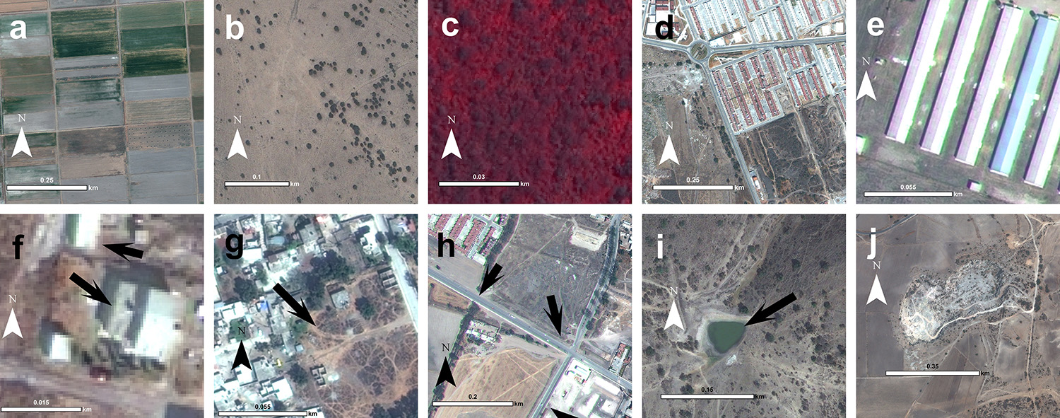
Through a DigitalGlobe Foundation imagery grant, we acquired 1263 km2 of GeoEye-1 VHR satellite data covering of the northern Basin of Mexico and southern Mezquital Valley. We used ArcGIS to process the data to create an integrated series of pan-sharpened and ortho-corrected images of the landscape (we used LiDAR data publicly available from the Mexican government to ortho-correct). Once processed, we overlaid the archaeological site data into our geodatabase. Rather than classify the incredibly heterogeneous imagery into land categories, we took advantage of the high-resolution imagery to visually assess contemporary land-use and manually assign each site into a set of categories based on our inspection and knowledge of the area: agriculture, grazing, forested, modern settlements, open lots, Roads, ponds or quarries.
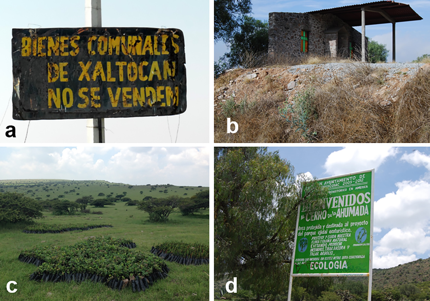
Our results reveal change, but also reason for optimism about the contemporary and future condition of archaeological resources. When these sites were originally recorded, almost all fell into farmland—either cultivation areas, pasture or mixed farming-pasture lands. Things remain similar today. More than 70 percent of the archaeological sites are located in agricultural spaces. Not surprisingly, most of the sites that were in farmland 40 years ago are still located in farmland, including areas for cultivation and for animal (mainly cattle) pasture. This consistency in land-use over time might mean that sites in farmland have a good chance of being preserved.
But a lot of change is evident, too. A huge array of modern construction and settlement exists: expansions of long-existing towns, shopping centers, gas stations, chicken production facilities, hotels, roads and spatially enormous condominium complexes that (seen from space) look like factories or prison complexes. The development of these built spaces has affected archaeological sites. More than 20 percent of the archaeological sites recorded 40 years ago are either in modern settlements, roads or open lots of modern settlements. Determining the actual extent to which this construction has destroyed archaeological sites would require feet on the ground.
We expect some of these developments to affect the landscape more than others. A condominium complex or a shopping center built by a commercial developer will spread across the landscape differently than one connected to population increases in local communities. The latter might be mediated by community—and possibly familial—institutions, many of which have existed for centuries. Settlement expansions in such places might occur gradually at a low scale of intensity without the excavation of deep foundations. Commercial infrastructure, in contrast, develops rapidly with less regard for preexisting cultural and natural landscapes and with greater impact on cultural resources and entire ecosystems.
Finally, we should not expect that archaeological sites in agricultural land are necessarily preserved. Increased tractor use has led to both deep plowing and chisel plowing. Tractors also enable farmers to more easily clear land of debris and obstacles, including mounds. We have undertaken select ground-truthing, which has demonstrated the negative impact of technological intensification in farming and land clearance. Many sites recorded with mounds no longer have them, although surface concentrations of artifacts still exist in the site areas.
Our methodology was straightforward: (1) compile satellite imagery for the Basin of Mexico; (2) superimpose the locations of archaeological sites over the imagery; (3) determine what the present land use is for each site (i.e., modern settlement, road, farming, forest, etc.); and (4) compare the present land use with the land use the archaeologists recorded. We hoped that using the contemporary satellite data would let us see what is going on around archaeological sites today and assess land-use over time. In this way, we hoped to reveal the potential threats to archaeological resources and offer insights into how the landscape has transformed in response to economic, social, environmental and political changes in Mexico.
Through a DigitalGlobe Foundation imagery grant, we acquired 1263 km2 of GeoEye-1 VHR satellite data covering of the northern Basin of Mexico and southern Mezquital Valley. We used ArcGIS to process the data to create an integrated series of pan-sharpened and ortho-corrected images of the landscape (we used LiDAR data publicly available from the Mexican government to ortho-correct). Once processed, we overlaid the archaeological site data into our geodatabase. Rather than classify the incredibly heterogeneous imagery into land categories, we took advantage of the high-resolution imagery to visually assess contemporary land-use and manually assign each site into a set of categories based on our inspection and knowledge of the area: agriculture, grazing, forested, modern settlements, open lots, Roads, ponds or quarries.
Our results reveal change, but also reason for optimism about the contemporary and future condition of archaeological resources. When these sites were originally recorded, almost all fell into farmland—either cultivation areas, pasture or mixed farming-pasture lands. Things remain similar today. More than 70 percent of the archaeological sites are located in agricultural spaces. Not surprisingly, most of the sites that were in farmland 40 years ago are still located in farmland, including areas for cultivation and for animal (mainly cattle) pasture. This consistency in land-use over time might mean that sites in farmland have a good chance of being preserved.
But a lot of change is evident, too. A huge array of modern construction and settlement exists: expansions of long-existing towns, shopping centers, gas stations, chicken production facilities, hotels, roads and spatially enormous condominium complexes that (seen from space) look like factories or prison complexes. The development of these built spaces has affected archaeological sites. More than 20 percent of the archaeological sites recorded 40 years ago are either in modern settlements, roads or open lots of modern settlements. Determining the actual extent to which this construction has destroyed archaeological sites would require feet on the ground.
We expect some of these developments to affect the landscape more than others. A condominium complex or a shopping center built by a commercial developer will spread across the landscape differently than one connected to population increases in local communities. The latter might be mediated by community—and possibly familial—institutions, many of which have existed for centuries. Settlement expansions in such places might occur gradually at a low scale of intensity without the excavation of deep foundations. Commercial infrastructure, in contrast, develops rapidly with less regard for preexisting cultural and natural landscapes and with greater impact on cultural resources and entire ecosystems.
Finally, we should not expect that archaeological sites in agricultural land are necessarily preserved. Increased tractor use has led to both deep plowing and chisel plowing. Tractors also enable farmers to more easily clear land of debris and obstacles, including mounds. We have undertaken select ground-truthing, which has demonstrated the negative impact of technological intensification in farming and land clearance. Many sites recorded with mounds no longer have them, although surface concentrations of artifacts still exist in the site areas.
 Studying the conditions of archaeological sites in relation to land-use from the 1970s to today offers an unprecedented opportunity to document changing landscapes around Mexico City. The dynamics of this process over the past half-century can be examined in the future via historical analysis of remote sensing data (air photos from the 1950s, public satellite data from the 1970s to today, and commercial satellite data like we used here). DigitalGlobe satellite imagery enabled us to rapidly assess the equally rapidly changing status of cultural resources in this area. We approach this issue not simply as technicians, but as historical social scientists—anthropological archaeologists. When viewed from this vantage, archaeologists can become important interlocutors not only of the past, but also of the present and the future.
Christopher Morehart is associate professor at the School of Human Evolution and Social Change, Arizona State University. John Millhauser is an assistant professor of anthropology at North Carolina State University.
Studying the conditions of archaeological sites in relation to land-use from the 1970s to today offers an unprecedented opportunity to document changing landscapes around Mexico City. The dynamics of this process over the past half-century can be examined in the future via historical analysis of remote sensing data (air photos from the 1950s, public satellite data from the 1970s to today, and commercial satellite data like we used here). DigitalGlobe satellite imagery enabled us to rapidly assess the equally rapidly changing status of cultural resources in this area. We approach this issue not simply as technicians, but as historical social scientists—anthropological archaeologists. When viewed from this vantage, archaeologists can become important interlocutors not only of the past, but also of the present and the future.
Christopher Morehart is associate professor at the School of Human Evolution and Social Change, Arizona State University. John Millhauser is an assistant professor of anthropology at North Carolina State University.