Hurricane Dorian made landfall in the Bahamas on September 1, 2019. According to Mercy Corps, a nongovernmental humanitarian aid organization, more than 75% of homes on the Abaco Islands were destroyed in the storm, and Great Abaco Island suffered 87% of the Bahamas’ overall hurricane damages. Vulnerable communities were destroyed, thousands of people were displaced, and hundreds of people were reported missing or dead.1
International Organization for Migration officers on Great Abaco Island reported removing 100 cubic meters of debris per day in October 2019.2 In November 2019, the Bahamas’ Ministry of Health said Hurricane Dorian created 1.3 billion pounds of debris and estimated it would cost approximately $74 million to clear.3
Two years after the natural disaster struck the island nation, recovery efforts remain underway and have far to go, according to Maxar analysis. The COVID-19 pandemic hampered recovery and reconstruction efforts early on, forcing aid groups like All Hands and Hearts, an NGO that rebuilds homes and schools, to temporarily suspend operations because of its volunteer-based model and supply chain delays, according to the organization’s operations manager.4 The pandemic continues to be a major obstacle to Bahamian recovery, as the Central Bank of the Bahamas projected only marginal growth for 2021 because of the COVID-19 pandemic.5
For this edition of Maxar Spotlight, we examined building repair and vegetation health as well as public sentiment surrounding recovery efforts. Our experts used high-resolution satellite imagery, Geospatial Human Imagery Verification Effort (GeoHIVE), on-the-ground surveying and the Normalized Difference Vegetation Index (NDVI) to improve situational awareness and reveal change over time, verify features of interest, monitor local opinions and observe vegetation recovery.
Read the full periodical to gain a better understanding of how Maxar’s Earth Intelligence capabilities reveal patterns of life and insights to predict, mitigate and resolve crisis and conflict.
Fill out the form to access the latest edition and subscribe to the Maxar Spotlight:
Sneak peek: excerpt from Maxar Spotlight, Vol. 32
GeoHIVE identified the extent of damage in the Bahamas just days after Hurricane Dorian made landfall. Analysts compared high-resolution Maxar imagery prior to Hurricane Dorian with imagery captured after the hurricane passed to classify the visible difference in building footprints and roof damage. Visible destruction (red), visible damage (gold) and no visible damage (green) were recorded.
In 2021, the GeoHIVE team analyzed the same neighborhood using the latest Maxar imagery. Between September 11, 2019, and March 13, 2021, most homes were rebuilt (yellow), while those with no visible damage after the hurricane remained visibly unchanged (green). Four destroyed homes were not rebuilt (orange).
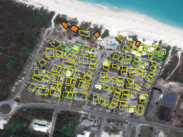
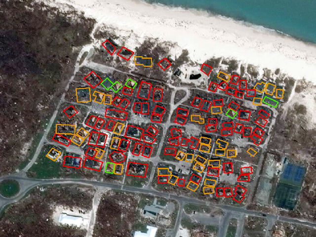
Satellite imagery showing the comparison of the destruction, September 11, 2019, and the recovery efforts, March 13, 2021, in Treasure Cay Beach, Bahamas.