Following any natural disaster, the affected nation’s public health becomes a key area of focus in response efforts, especially amid a global pandemic that has already strained public health resources worldwide. The mid-January 2022 eruption of the Hunga Tonga Hunga Ha'apai volcano on the Pacific island nation of Tonga triggered a catastrophic tsunami with waves up to 49 feet high along the country’s coastlines.
Maxar responded to the eruption and subsequent tsunami by releasing data of the affected areas as part of our Open Data Program, which helps organizations working on the front lines of a disaster increase their effectiveness. Immediate access to high-resolution satellite imagery for search –and rescue missions is critical, and ongoing analysis for second- and third-order effects, such as public health, is also vital after a disaster.
Significant flooding from the tsunami left vulnerable areas littered with debris from damaged buildings and inundated with standing water, posing a significant threat to public health. Standing water can accelerate the spread of mosquito-borne diseases, and Tonga’s tropical climate contributes to year-round transmission of dengue fever, especially in highly populated areas.
In March 2018, at least 70 cases of dengue fever were reported on the island after Tropical Cyclone Gita. Following the cyclone, engineers noted that floodwaters did not drain quickly enough because of limited technology and minimal organization by the Tongan government. Public health officials stressed the importance of identifying areas most affected by flooding to allocate resources and reduce further transmission of dengue fever.
Applying these lessons learned, Maxar analysts leveraged the company’s advanced imagery analytics after Hunga Tonga Hunga Ha'apai’s eruption to identify flooded areas in Tonga’s capital, Nuku’alofa, using Maxar’s high-resolution satellite imagery and Sentinel 2 moderate-resolution satellite imagery.
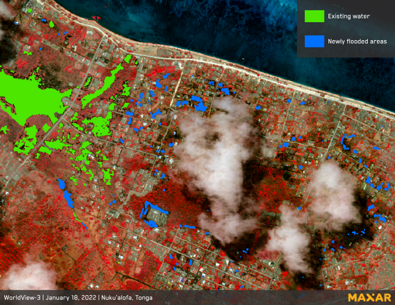
Analysis of Maxar satellite imagery revealed existing water bodies before the Hunga Tonga Hunga Ha'apai eruption and new areas of standing water after the tsunami triggered by the eruption. Maxar analysts applied an automated water classification algorithm to identify areas of standing water and determined that nearly 20,000 square meters were still inundated as of January 18, 2022.
The following map depicts an area inundated by tsunami flooding; false-color infrared imagery was used to visualize areas inundated with water (represented in blue) and vegetation (red). False-color infrared imagery leverages the spectral resolution of Maxar’s satellite constellation to differentiate among physical features.

False-color infrared imagery shows newly flooded areas on Tonga following the tsunami triggered by the eruption of the Hunga Tonga Hunga Ha'apai volcano.
Automatic water classification algorithms developed by Maxar geospatial analysts enable rapid quantification of inundated areas of standing water to assist government and nongovernment organizations (NGOs) in both immediate disaster relief and longer-term public health response.
Communities that derive drinking water from communal tanks are at increased risk of being exposed to dengue fever, as the tanks are more likely to be contaminated with floodwaters. In the Tongan village of Sia’atoutai, which is in proximity to identified flooded areas, more than 40% of residents rely on communal tanks for drinking water. As a result, Sia’atoutai and the surrounding area could be more vulnerable to disease outbreaks following flood-type disasters.
Maxar advanced imagery analysis can be leveraged by a variety of groups—from NGOs and disaster response teams to insurance managers—to evaluate pre- and post-event water extent as well as other features. Our unclassified, comprehensive analytic reports combine proprietary and open-source data with cutting-edge tools and advanced analytic expertise to provide insight on complex challenges such as emergency preparedness and disaster response or changing environmental and geopolitical conditions.
Maxar’s bimonthly Spotlight periodical offers an in-depth look at other critical, real-world problems through the lens of Maxar’s innovative geospatial analytics.
Subscribe