
Editor’s Note: This blog post is adapted from a presentation by Carrie Drake, Maxar’s Director of Government Marketing, in September 2021 at the Intelligence and National Security Summit hosted by the Intelligence and National Security Alliance and AFCEA International. Click here to view the video of the speech.
Partnership, collaboration and integration are more important than ever in this burgeoning era of great power competition. The strength of Maxar’s combined offerings can help the United States defense and intelligence communities reach their modernization goals and maintain decision advantage in an increasingly complex world.
Maxar has executed against the U.S. government’s commercial remote sensing requirements exceptionally well for more than 20 years. In today’s world, national security relies on multidomain operations and rapid, intelligent decision-making to provide the United States and its allies a strategic advantage. Maxar continues to innovate and deliver on its heritage of advanced satellites and Earth imagery to provide customers with near real-time insights for accelerated decision-making.
We go beyond pixels to provide assured, connected, persistent and resilient geospatial intelligence (GEOINT). We listen and respond in earnest to customer challenges and are actively developing leading-edge technologies that can enable automated tasking, collection, processing, exploitation and dissemination across the National System for Geospatial Intelligence.
Space-based intelligence for rapid decision-making will be a critical tool in the multiforce, multidomain landscape of the near future. Through internal research and development, exciting acquisitions and dynamic industry partnerships, Maxar has expanded our offerings to include secure data and communications infrastructure, mobile access terminals, 3D foundation data and precision georegistration, artificial intelligence and machine learning (AI/ML) tools, and much more.
Sensor-to-decision attributes and enabling technologies
Combined, these elements comprise what Maxar calls our sensor-to-decision workflow. This methodology, which provides exceptionally fast insights from satellite imagery, can be applied to a wide range of national security challenges.
Maxar’s low-latency sensor-to-decision workflow is ideal for situations that can be described using one or more of these five attributes:
- Persistent: Decision-makers require continuous visibility and information.
- Disconnected: Data access is challenging in certain environments.
- Widespread: The task of the human analyst is exponentially improved with AI/ML.
- Time-sensitive: Mission success is often directly tied to reducing the time between question and answer.
- High-risk: Ensure the safety of U.S. warfighters and our allies.

Persistent: Maxar’s 125-petabyte, 20-year archive of high-resolution satellite imagery is ideal for detecting and monitoring change such as glacier melt caused by global warming.

Disconnected: Maxar deep learning technology applied to our WorldView-3 satellite imagery is used to detect elephants in remote areas of Africa.

Widespread: Unexpected bottlenecks, such as the Suez Canal obstruction caused by the Ever Given ship in March 2021, can affect the entire global supply chain.
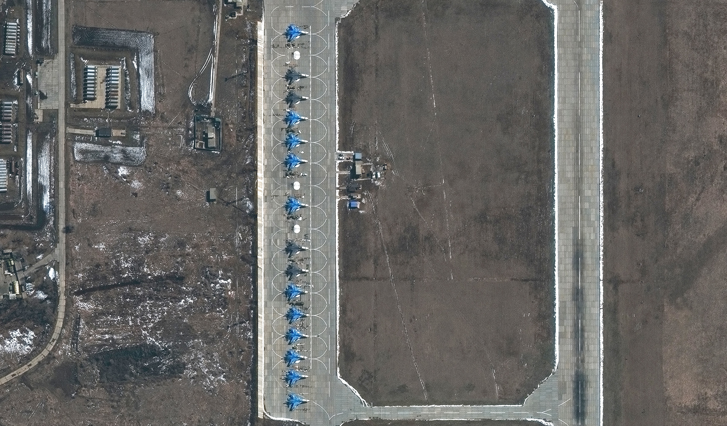
Time-sensitive: Maxar technology can help identify and monitor military buildup around the world, such as these Su-34 fighter-bombers on the flight line in Morozovsk, Russia, in March 2021.
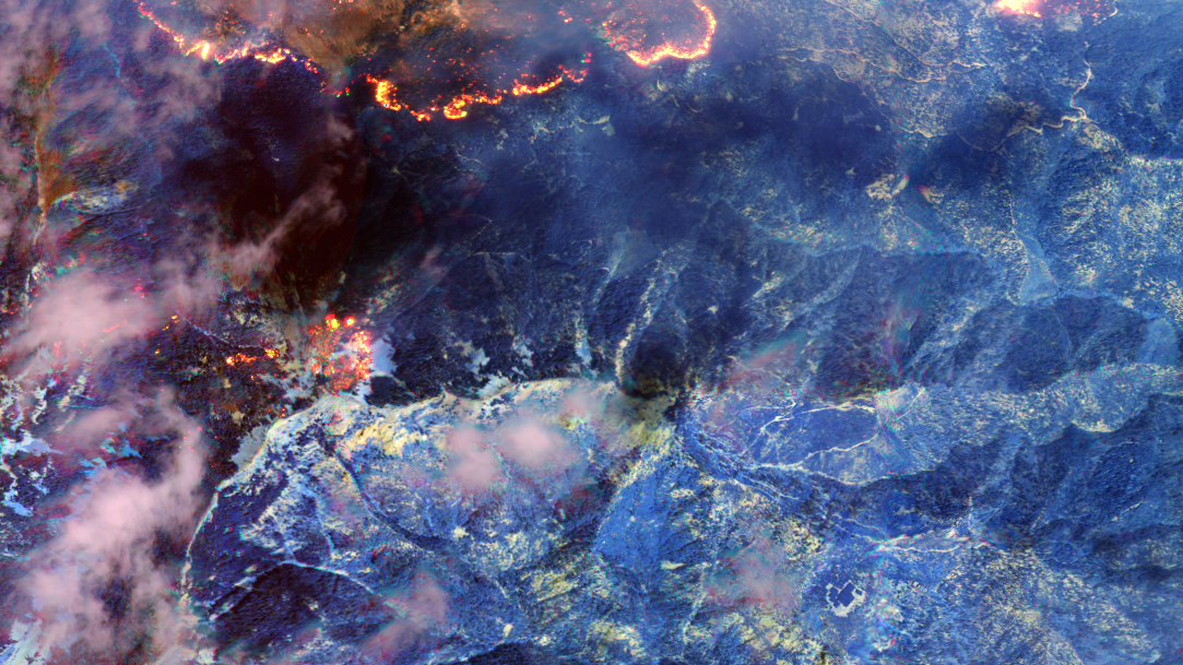
High-risk: Shortwave infrared imagery from Maxar’s WorldView-3 satellite can see through smoke to pinpoint active fire lines for first responders.
Maxar’s sensor-to-decision workflow is ideal for situations that are persistent, disconnected, widespread, time-sensitive or high-risk.
Four key technological innovations are enabling this advanced GEOINT decision-making:
- High-resolution imagery: The sensor-to-decision process begins with capturing the best data. With the highly anticipated launch of WorldView Legion, the Maxar constellation of high-performance satellites will offer global revisit rates up to 15 times per day in addition to increased direct tasking opportunities and even more imagery at 30 cm class resolution.
- Mobile access terminals: Delivering high-power computing at the tactical edge is essential to achieve decision superiority. Maxar’s data provider-agnostic Tactical Access Program provides near real-time access to electro-optical and synthetic aperture radar data and processing— even in low-bandwidth environments.
- Precision 3D Registration (P3DR): For multisensor data to align with the real world it must be georegistered. Other methods are labor- and time-intensive, but Maxar’s P3DR uses sophisticated algorithms to quickly georegister imagery at any spot on the globe with 3 m accuracy—roughly the length of an SUV.
- AI/ML for broad area surveillance: Maxar’s AI/ML capabilities automatically detect objects, identify patterns of life or generate targeting data from vast datasets, identifying anomalies for decision-makers.
Maxar is one of the only companies to offer all these end-to-end capabilities necessary to rapidly reveal insight from space.
Maxar’s combined offerings in action
Our combined offerings already empower the U.S. Department of Defense (DOD) and intelligence community (IC) to better monitor, understand and respond to current events, deter threats and ensure global security.
Maxar is the prime contractor for the U.S. Army’s One World Terrain (OWT) program, which delivers 3D terrain and information services that support a fully accessible virtual representation of the Earth through the U.S. Army network. In addition to training, OWT is expanding to support 3D geospatial components across the entire Army, to include mission planning, navigation, situational awareness and targeting.

This geospecific image of Kabul, Afghanistan, leverages Maxar’s P3DR technology to fuse drone data collected by the Institute for Creative Technologies with the authoritative Maxar foundation that generates 3D training content for the U.S. Army’s One World Terrain program.
We also provide critical GEOINT to soldiers in remote locations via the highly portable, Maxar-built U.S. Army Remote Ground Terminal.
Maxar leverages space-based optical and radar imagery, advanced ML, automation and low-latency alerting to deliver vessel detection and critical domain awareness to maritime organizations around the world.
Our imagery provides insight not only for DOD and IC customers but also to global news outlets seeking ground truth in dangerous or hard-to-reach locations. For example, in April 2021, The Wall Street Journal used Maxar’s high-resolution satellite imagery to inform its reporting on Russia’s expanding buildup of combat aircraft and other military equipment along the Ukraine border.
In August 2021, Maxar WorldView-3 imagery of the airport in Kabul, Afghanistan, provided visual evidence to help the world understand the scale and scope of the chaos taking place on the ground as people sought evacuation. These images were shared in more than 700 international publications.

This Maxar satellite image shows chaos on the tarmac at Hamid Karzai International Airport in Kabul, Afghanistan, on August 23, 2021.
Supporting GEOINT innovation
Just as important as our leading-edge combined offerings is Maxar’s long history of partnership with the U.S. government. Maxar has been a trusted DOD and IC partner for more than two decades, during which we have gained a deep understanding of national security missions and challenges. Maxar takes pride in our role as an industry thought leader regarding transparency, data sharing and relationship-building.
As a pioneer in both Space Infrastructure and Earth Intelligence, with offerings that touch all aspects of the GEOINT life cycle, we are uniquely positioned to keep a pulse on the industry. Maxar’s experts can see across the U.S. government customer base to connect the dots and identify shared mission areas, redundancies and opportunities for partnership and collaboration.
At a time when America is evolving its national security posture to focus on near-peer adversaries, having a preeminent domestic GEOINT industry is imperative. U.S. adversaries will operate with far greater speed, scale and sophistication than those we have faced in the recent past, so we need our best and brightest minds working on capabilities that give our nation the information advantage.

Maxar’s manufacturing facility in Palo Alto, California
Maxar believes the promise of GEOINT for U.S. and global security can be achieved through ongoing commitment to robust public-private partnerships among IC stakeholders from government, industry and academia. Maxar is proud to be part of this innovative ecosystem, and we invite you to learn more about the strength of our combined offerings and to partner with us toward a more secure world for all.
From sensor to decision,
see what's possible with the strength of Maxar's combined offerings.