January 28, 2021. Flying high above the Rocky Mountain region of the United States, a Maxar satellite downlinks new images for the Science Channel television show “What on Earth?”
That may sound like the start of a new episode—and it is! For nine seasons, “What on Earth?” producers have been solving Earth’s mysteries using a combination of Maxar satellite imagery and expert analysis. Each story on the show starts with a unique image of Earth and then explores different theories for what’s happening on the ground.
Since 2017, Maxar’s Ken Joyce has been contributing to the show as an imagery analyst.
“On the show, I leverage Maxar’s SecureWatch
subscription service to expand upon the main image with additional imagery and tools to help solve the mystery,” said Ken Joyce, Maxar’s Director of Product Management. “In my favorite stories, I look back in time to see how the area of interest has changed, or I use combinations of spectral bands, which were collected by our satellite to reveal things otherwise hidden to the human eye.”

In addition to imagery experts like Ken, the producers interview other professionals, such as historians, biologists and former intelligence analysts, to bring different perspectives to understanding the image.
Filming the show
Maxar prepares to film each new season by reviewing a list of story ideas from the producers and figuring out which ones are best suited for Ken’s level of expertise. For about 15 stories per season, Ken works with Maxar’s Collection Planning team to task new imagery collections of the locations while digging through Maxar’s 125-petabyte imagery archive using SecureWatch. Archival imagery from the last 20 years is often the key to understanding and describing what is happening in the location by comparing the images from past to the present.
Before the COVID-19 pandemic, the show’s producers and videographers would visit Maxar’s headquarters twice a year for a total of four filming days. Sometimes Ken was joined by other Maxar employees who lent their expertise to the show. In one story, Heather Shocker, who has studied volcanology, played a pivotal role in unveiling the reason trees were mysteriously dying in a mountainous region of California.
, and Maxar’s Heather Shocker filmed in November 2019 (right).")
Maxar’s Ken Joyce filmed at Maxar’s headquarters in June 2018 (left), and Maxar’s Heather Shocker filmed in November 2019 (right).
During the pandemic, the team has found creative ways to continue capturing new stories for Season 9, which is currently airing new episodes each week on the Science Channel. The team adopted social distancing and safety protocols that included the director joining remotely via Zoom so only Ken and the videographer (who wore a mask) were physically present. They converted a historic house in Denver for taping, as the Maxar facility has been restricted to employees.

Maxar’s Ken Joyce snapped a quick selfie while taping a new episode for Season 9 in November 2020. Because of COVID-19, the U.K.-based director could not physically be on the set and can be seen on a Zoom call in the background.
Favorite stories
Ken has appeared in more than 20 stories for the “What on Earth?” show. These are three of his favorite stories:
“Afghan Meth Labs”
In the Season 9 premiere, “What on Earth?” examined a Maxar satellite image of Farah province, Afghanistan, where a mysterious pool recently appeared next to a building. Ken used SecureWatch to demonstrate that other buildings in the area had the same visual signature. His testimony, along with interviews with other experts, revealed these buildings were likely part of a growing network of methamphetamine labs in the region. To learn more about this topic, read Maxar’s Spotlight report about Afghanistan’s booming drug economy.

In this SecureWatch screenshot, a near-infrared image shows a suspected meth lab location. Red indicates healthy vegetation, and a mysterious pool, the primary signature for a meth lab, glows fluorescent blue.
“Mud Volcano”
In Season 6, Episode 1, an image showing a mud-covered area in East Java, Indonesia, served as the centerpiece of a story. Ken looked back in time to show that the location used to be a busy metropolitan area until mud started oozing from the ground in 2005.
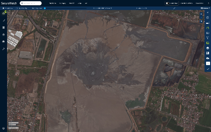

These SecureWatch screenshots show before (2001, left) and after (2018, right) images of the location affected by a mud volcano eruption.
“Parachuting Sheep”
The premiere for Season 7 included a story about odd patterns visible from space in the Ethiopian desert, where the Italian army is known to have parachuted in live sheep to feed occupying troops during World War II. Ken dialed up the zoom level with Maxar’s 30 cm resolution satellite imagery to find out what was really causing the patterns.

This behind-the-scenes photo shows one of the setups used to film the “parachuting sheep” story for “What on Earth?”
The newest season of “What on Earth?” is currently airing new episodes Thursday nights on the Science Channel. If you’d like to learn more about Maxar’s SecureWatch, request a custom demo.