Today marks the 50th anniversary of Earth Day. After so many years of raising awareness about the crisis facing the environment, this year’s theme is climate action: how can people make a difference on climate change?
At Maxar, our Earth Intelligence and Space Infrastructure capabilities have the power to create change For A Better World. As it specifically relates to the environment and climate change, our geospatial data provides the context needed to operationalize climate initiatives. High-resolution imagery can guide and evaluate commitments like net-zero and net-negative supply chains, greening efforts and other climate interventions. It can also help us understand the trade-offs with various interventions as relates to effects on natural resources, the economy and other sectors. In all of these analyses, satellite imagery increases transparency in decision-making and help us de-risk our futures.
For Earth Day, we would like to showcase some of these efforts that we are accomplishing with customers and partners around the world:
Renewable Energy Infrastructure
The United Nations Sustainable Development Goal (SDG) #7 calls for access to affordable and clean energy. Maxar’s technology can help transition to clean energy sources, forecast potential for renewable energy sources and identify gaps in clean energy access.

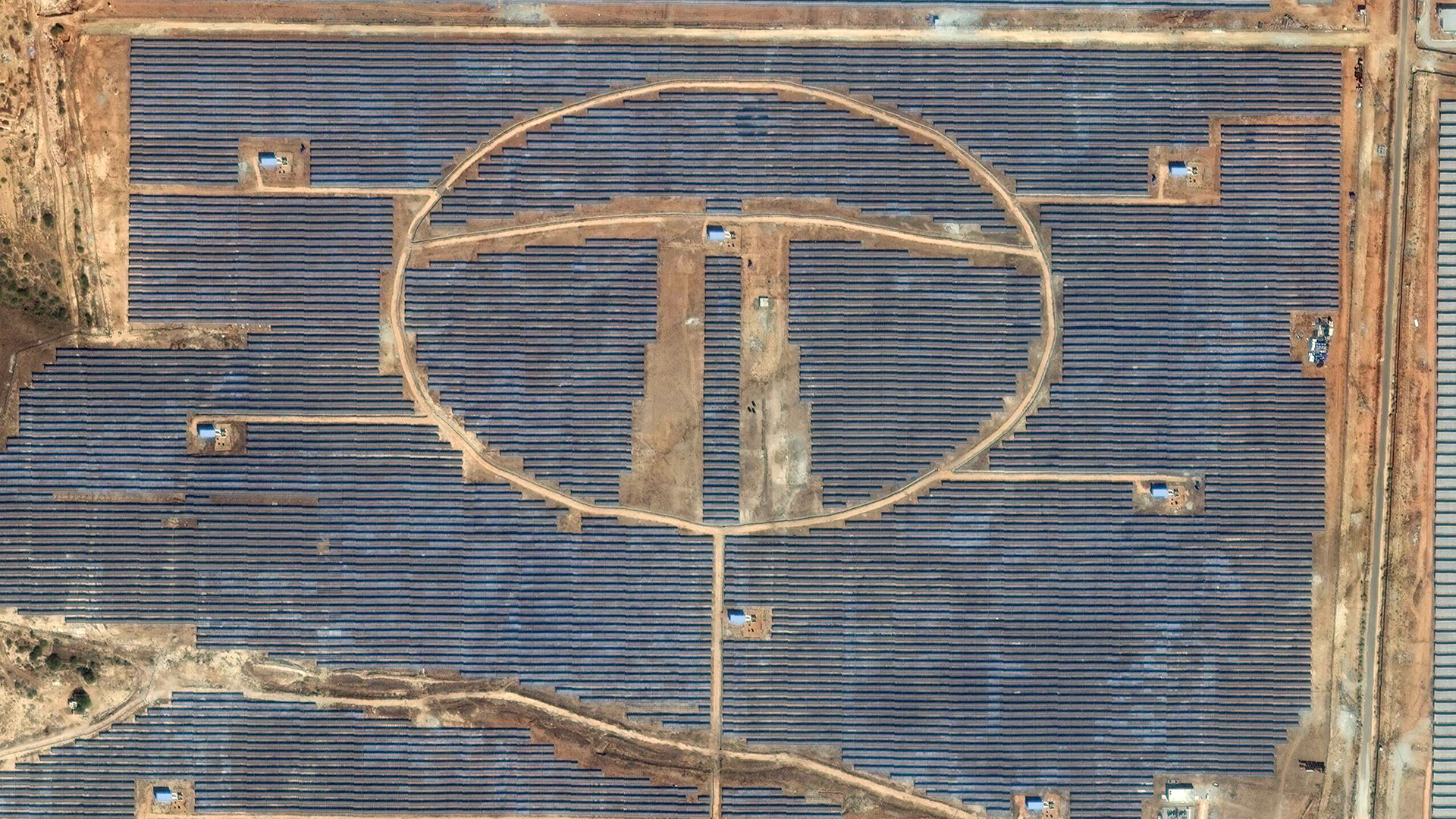
Part of the National Renewable Energy Laboratory (NREL) focuses on solar panel projects. Ground-mounted solar projects can provide additional value beyond the clean energy they produce. When groundcover underneath the solar arrays is planted with native vegetation and pollinator habitat, it can benefit soil quality, water management, beneficial insect populations and nearby agricultural yields. NREL uses Maxar’s high-resolution satellite imagery and Geospatial Big Data platform (GBDX) to identify groundcover at solar installations across the country to understand where pollinator-friendly solar projects are providing these benefits.
Food Security

UN SDG #2 focuses on zero hunger by rethinking how people grow, share and consume food. Maxar’s resolution and spectral diversity support important food security analyses like mapping and monitoring agricultural areas, understanding the effects of agricultural practices on natural resources and adapting to various shocks and stressors on-farm.
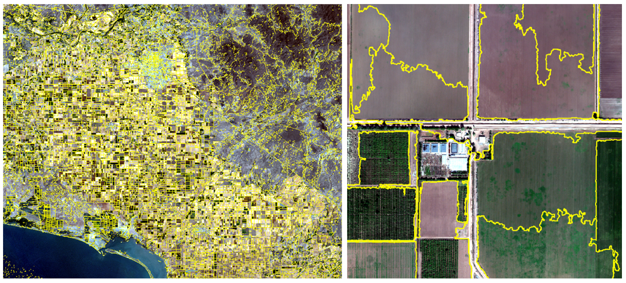
CGIAR, a global food security research partnership (formerly the Consultative Group for International Agricultural Research), leverages Maxar’s 110 petabyte satellite imagery library and geospatial big data platform (GBDX) for efforts related to conservation farming in developing countries. For example, CGIAR scientists use GBDX to detect smallholders’ field management practices at scale, such as no-till in Mexico and row-planting in Ethiopia. This information helps CGIAR to develop strategies for farmers to sustainably increase farm productivity and soil health while conserving natural resources, biodiversity and labor.
Environmental Improvements

UN SDG #15 directs attention toward maintaining the biodiversity of life on land and reducing environmental degradation. The rich details in Maxar imagery enable answers to important conservation questions around the health and extent of our natural resources and biodiversity, drivers of change and how best to protect them.
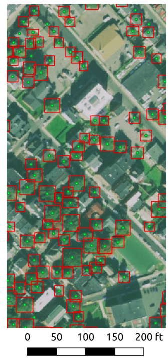
Green City Watch, an Amsterdam-based geospatial AI firm specializing in urban ecological engineering, created a new technology called TreeTect™ that offers a smarter way to identify, map and track one of the most important urban infrastructure assets: trees. The traditional methods still used today to inventory, map and monitor urban trees are in need of an upgrade. Urban foresters and arborists want up-to-the-minute, real-time information on the status of their urban forests. The reason they don't have this data is that it's simply too expensive and takes too long to gather that information on the ground. That's where high-resolution remote sensing steps in, offering the same information, and perhaps even more, in near real-time. By combining artificial intelligence, Maxar’s satellite imagery and geospatial technology, it’s possible to analyze the city's forestry down to each individual tree using TreeTect. Smart cities are using cutting-edge Industry 4.0 technology for everything today, from the Internet of Things sensors to health and transport connectivity, so why not also use it to protect and enhance nature as well?
Whether you need detailed snapshots of every tree or farm or solar array, very high-resolution satellite imagery offers a consistent source of truth about our changing planet. In those pixels, we can better understand the interplay of the human and natural landscapes to make informed decisions about how to best protect our limited resources For a Better World.
Visit our Content Hub to learn more about Maxar’s climate action efforts.