Since the dawn of the Space Age in the late 1950s, humans have been launching objects into space for military, commercial, and scientific purposes. Today, space environment models are used to estimate total numbers of objects in orbit, revealing there are 29,000 objects larger than 10 cm, 750,000 from 1 to 10 cm, and more than 166 million from 1 mm to 1 cm [1]. Maxar’s DigitalGlobe satellites orbit among the ever-growing debris cloud. It is imperative that debris objects are tracked for the safety of all satellites, including DigitalGlobe’s.
[caption id="" align="aligncenter" width="800"]

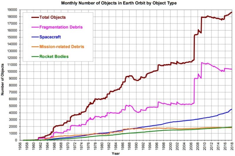
Evolution of published space object population and its composition by class. Credit: NASA Orbital Debris Quarterly News, Vol 22, Issue 1, Feb 2018[/caption]
Current satellite operators rely on the United States Department of Defense Combined Space Operations Center (CSpOC) for space object identification and tracking. The CSpOC maintains a catalog of space objects larger than 10 cm in Earth orbit and publishes that catalog publicly, which now contains almost 20,000 objects [2]. However, the CSpOC is a military organization, and their operational procedures do not always prioritize commercial satellite operations, and the services provided are limited in their transparency, timeliness, and machine-to-machine interactivity with an operator’s conjunction assessment (CA) system (a conjunction is when two space objects pass within a pre-defined distance threshold).

LeoLabs is a commercial provider of high-performance tracking and mapping data for low Earth orbit (LEO) and operates a worldwide network of radars. The company’s cloud-based software platform turns the radar data into real-time, actionable information about where debris is located on orbit. This information is delivered through an application programming interface (API) and through web-based dashboards and visualization tools. The API enables full, end-to-end automation and can be integrated easily into custom applications. With its two radars, LeoLabs provides valuable tracking data and resolved state vectors on a subset of LEO objects. Beginning in 2019, LeoLabs will deploy several more radars to increase the revisit rate and allow for the detection of small, currently untracked debris.
DigitalGlobe has been actively involved in the CA community, participating in workshops, working groups, and conferences throughout the world for years. DigitalGlobe decided to test LeoLabs’ new technology in a pilot program to explore the benefits of using multiple data sources for debris tracking and collision avoidance (COLA). The hypothesis was by using multiple data sources as inputs, operators can create more informed decisions about their on-orbit assets and verify the data from each source. Additionally, operators gain an advantage in cases where one data provider has information about a given debris object and other providers do not.
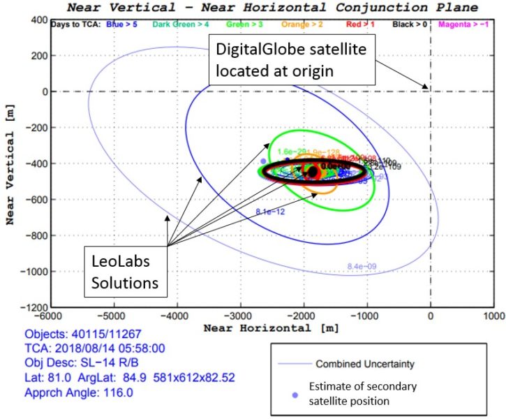
With the API developed by LeoLabs, DigitalGlobe seamlessly incorporated LeoLabs data into the company’s existing CA system. In the time DigitalGlobe has worked with LeoLabs’s data, several on-orbit conjunctions have been evaluated. The hypothesis proposed at the beginning of the project turned out to be true. Not only do we have more data about debris objects, but we are also finding advantages with instantaneous machine-to-machine interactivity: the DigitalGlobe and LeoLabs programs are talking to each other faster and we’re getting refreshed data when needed more quickly. As an example, here’s a conjunction between WorldView-3 and a Tsyklon-3 rocket body:

In the above figure, the conjunction between WorldView-3 and the Tsyklon-3 rocket body is considered at the time of closest approach (TCA) – this graph is generated and updated continuously as data is received from up to 7 days before all the way to TCA. WorldView-3’s location is noted on the graph and the Tsyklon-3 rocket body’s estimated position at TCA is located at the colored dots. The ellipses represent the uncertainty associated with each estimation of the rocket body, and the color represents the time left before TCA (legend at the top of the graph). This example demonstrates an ideal tracking and uncertainty reduction scenario, where each successive solution has nested uncertainty ellipses and decreasing final state uncertainty. The fact that the ellipses from LeoLabs and the CSpOC overlap at the predicted miss point increases confidence that the conjunction does not require any operator action and the risk to WorldView-3 is negligible.
The unique, new process of incorporating LeoLabs data into the DigitalGlobe CA system is important because it introduces an independent data source for orbital debris, and reduces collision risk. LeoLabs provides supplementary information to the CSpOC’s existing services and provides a redundant mechanism for gathering information when none is provided by the CSpOC. DigitalGlobe is supportive of this integrated commercial data and government data solution becoming standard among LEO satellite operators, which will benefit the entire space-faring community though collision risk reduction, preserving the space environment for use by all.
References:
[1]: K. Fletcher, Space Debris: The ESA Approach, European Space Agency, ISBN 978-92-9221-104-2, 2017.
[2]: Space-track.org, Space Situation Report, Accessed 21 Aug. 2018