 I was at an electronics store the other day and saw a UAV quad copter with a camera. Really cool technology – went straight on my wish list. It’s so easy to use: you hold it, you launch it, and in mere minutes you have a birds-eye view of the whole neighborhood. And assuming you’re a good enough pilot, you fly it back home to download the data it collects. With the right software and tools – and about $1,000 to buy the copter – you’re suddenly making scientific observations as part of the remote sensing community.
Next month, DigitalGlobe will be launching a new satellite into space. It’s called WorldView-4, and it’s on the opposite end of the remote sensing spectrum from that quad copter. We’ll never see or touch WV-4 again after launch, and we certainly won’t be able to just plug in a cable to download the data it collects. From what I understand, it’s also costing us a little more than $1,000.
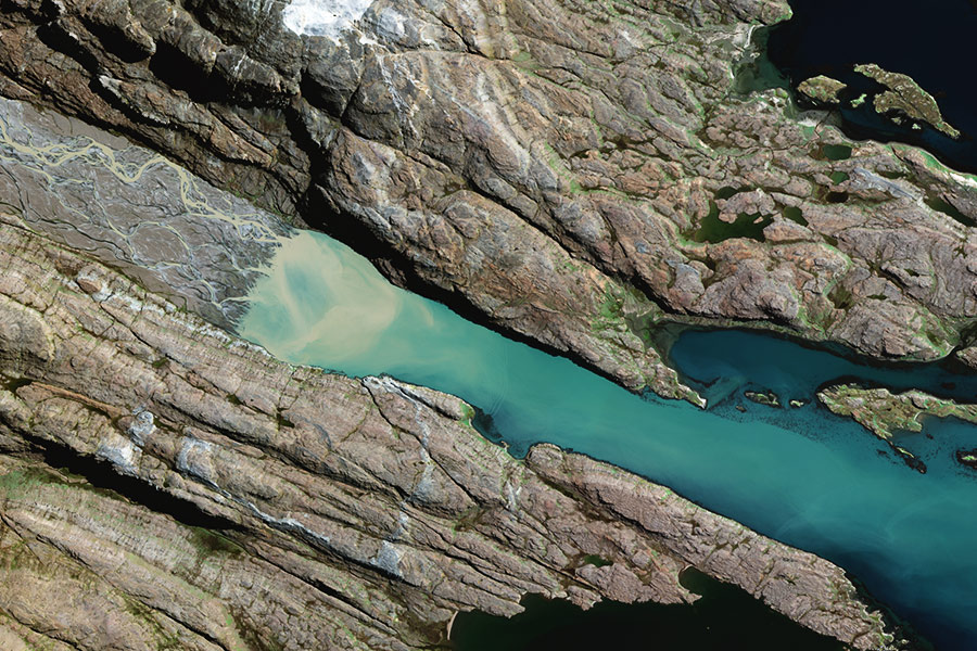
From a tech standpoint, WorldView-4 does a lot of things for us. It more than doubles our 30cm collection capacity, which is far and away the best in the industry. It takes some of the load off of WorldView-3, since we’ll now have two very similar versions of the industry’s best satellite for tasking instead of just one. In short, it helps us do everything we do even better than we do it today.
And as amazing as it is to launch a satellite, the ramifications of this event go way beyond that. There’s the ground system that allows us to command, operate and downlink information from our entire constellation. There are global teams of people that program commands and maneuver the satellites, and the software and platforms that enable us to distribute and interpret the data.
But the most important result from the launch is our increased ability to help solve global problems every single day. DigitalGlobe sends satellites into space so we can make observations of the entire planet, not just my neighborhood. We see every continent, every country, every border, every coastline and all the oceans in between. And our end users take those observations and use them to solve very real, very human problems every day. Here are just a few:
I was at an electronics store the other day and saw a UAV quad copter with a camera. Really cool technology – went straight on my wish list. It’s so easy to use: you hold it, you launch it, and in mere minutes you have a birds-eye view of the whole neighborhood. And assuming you’re a good enough pilot, you fly it back home to download the data it collects. With the right software and tools – and about $1,000 to buy the copter – you’re suddenly making scientific observations as part of the remote sensing community.
Next month, DigitalGlobe will be launching a new satellite into space. It’s called WorldView-4, and it’s on the opposite end of the remote sensing spectrum from that quad copter. We’ll never see or touch WV-4 again after launch, and we certainly won’t be able to just plug in a cable to download the data it collects. From what I understand, it’s also costing us a little more than $1,000.
From a tech standpoint, WorldView-4 does a lot of things for us. It more than doubles our 30cm collection capacity, which is far and away the best in the industry. It takes some of the load off of WorldView-3, since we’ll now have two very similar versions of the industry’s best satellite for tasking instead of just one. In short, it helps us do everything we do even better than we do it today.
And as amazing as it is to launch a satellite, the ramifications of this event go way beyond that. There’s the ground system that allows us to command, operate and downlink information from our entire constellation. There are global teams of people that program commands and maneuver the satellites, and the software and platforms that enable us to distribute and interpret the data.
But the most important result from the launch is our increased ability to help solve global problems every single day. DigitalGlobe sends satellites into space so we can make observations of the entire planet, not just my neighborhood. We see every continent, every country, every border, every coastline and all the oceans in between. And our end users take those observations and use them to solve very real, very human problems every day. Here are just a few:
- Helping people see the whole world by improving user experience in the world’s largest mapping platforms, mapping settlements and road networks in OpenStreetMap, and improving turn-by-turn directions for navigation and ride sharing.
- Enabling communications improvements like building out 5G networks to support smart cities and connected cars.
- Documenting environmental issues like monitoring invasive species, tracking and documenting illegal fishing and poaching, and detecting deforestation and monitoring forests on a tree-by-tree basis.
- Visualizing economic concerns like counting and measuring change in global economic indicators and detecting illegal tapping into pipelines and utilities.
- Supporting global security by keeping our nation (and other nations) safe, and working with NGOs on sociopolitical issues like slavery and human trafficking that impact thousands of lives.
 The addition of WorldView-4 to our constellation and the improvements we’re making to our associated systems, platforms, software and teams will enable our end users to solve even more problems with more accuracy and more confidence. If you want to learn more, see our products and developer page.
If you want to follow the launch, check out this microsite. And if you want to buy that quad copter, I just might know a backyard that would be perfect for its maiden voyage.
The addition of WorldView-4 to our constellation and the improvements we’re making to our associated systems, platforms, software and teams will enable our end users to solve even more problems with more accuracy and more confidence. If you want to learn more, see our products and developer page.
If you want to follow the launch, check out this microsite. And if you want to buy that quad copter, I just might know a backyard that would be perfect for its maiden voyage.