 A web-based application allowing users to autonomously detect new potential structures, human activity and roads near their assets utilizing DigitalGlobe high-resolution satellite imagery.[/caption]
One of the key lessons we learned along the way was that energy professionals need to have direct access to these types of services, or at a minimum the data they provide, directly within the Esri tools they use every day. So as a part of our product development iteration, we also focused on developing a way for Esri users who are also customers of our GBDX platform to directly request analytics on our imagery or view the results of the analytics produced by GBDX within Esri ArcMap using an add-in developed by DigitalGlobe.
[caption id="attachment_4996" align="aligncenter" width="800"]
A web-based application allowing users to autonomously detect new potential structures, human activity and roads near their assets utilizing DigitalGlobe high-resolution satellite imagery.[/caption]
One of the key lessons we learned along the way was that energy professionals need to have direct access to these types of services, or at a minimum the data they provide, directly within the Esri tools they use every day. So as a part of our product development iteration, we also focused on developing a way for Esri users who are also customers of our GBDX platform to directly request analytics on our imagery or view the results of the analytics produced by GBDX within Esri ArcMap using an add-in developed by DigitalGlobe.
[caption id="attachment_4996" align="aligncenter" width="800"] Results of GBDX analytic output of roads and structures detected in DigitalGlobe imagery
as viewed directly in Esri ArcMap with the GBDX add-in.[/caption] The ArcMap GBDX add-in tool enables mutual Esri and DigitalGlobe GBDX customers to directly request analysis or interact with the results of analysis from inside the ArcMap tool, then refine the outputs and share them via Esri technologies they already use, or make them consumable to other tools used in their workflows via Esri services. [caption id="attachment_4997" align="aligncenter" width="800"]
 Structures and features intersecting pipeline buffer zone along with DigitalGlobe Imagery within Esri ArcMap.[/caption]
DigitalGlobe and Esri have furthered our strategic partnership with several joint initiatives. We are working on integrating the best of the breed imagery processing and analytics tools from Esri including ArcGIS Image Server’s dynamic Image Services and Raster Analytics with DigitalGlobe’s GBDX platform and analytics to support the ever-growing ecosystem of Esri's user base; including Petroleum user groups.
The combination of native integration between GBDX analytical tools and ArcGIS Image Server will allow Esri users to leverage DigitalGlobe’s multi-spectral and super-spectral imagery for a multitude of applications over the entire spectrum of the project life cycle from upstream, midstream and downstream operations, and ranging from site selection and Seismic planning, environmental impact assessment, pipeline monitoring, facility monitoring and others.
Further, DigitalGlobe will be unveiling our new imagery search and discovery tool built on Esri technologies in the coming weeks which will represent an integral first step in delivering these capabilities for Esri users.
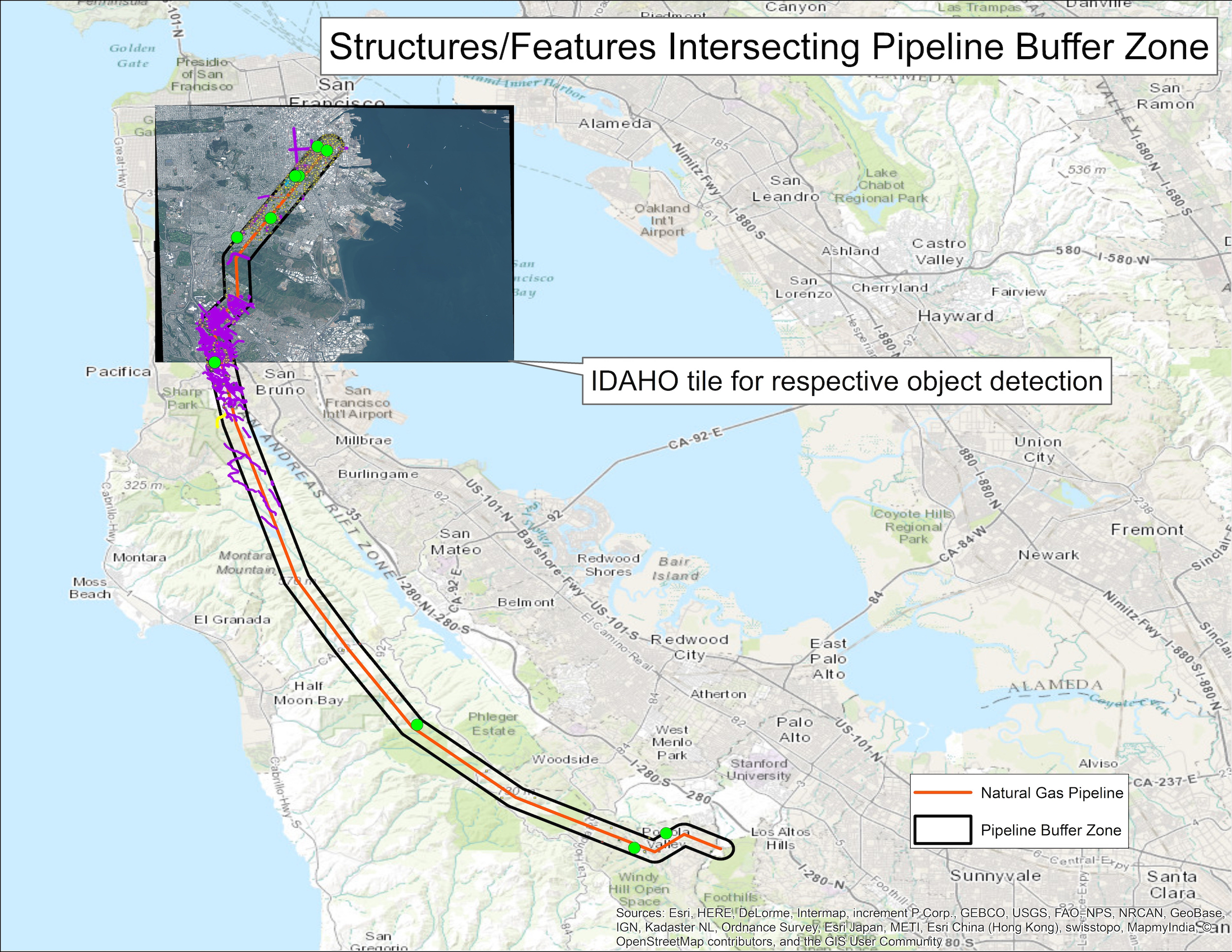
[caption id="attachment_4998" align="aligncenter" width="800"]
Structures and features intersecting pipeline buffer zone along with DigitalGlobe Imagery within Esri ArcMap.[/caption]
DigitalGlobe and Esri have furthered our strategic partnership with several joint initiatives. We are working on integrating the best of the breed imagery processing and analytics tools from Esri including ArcGIS Image Server’s dynamic Image Services and Raster Analytics with DigitalGlobe’s GBDX platform and analytics to support the ever-growing ecosystem of Esri's user base; including Petroleum user groups.
The combination of native integration between GBDX analytical tools and ArcGIS Image Server will allow Esri users to leverage DigitalGlobe’s multi-spectral and super-spectral imagery for a multitude of applications over the entire spectrum of the project life cycle from upstream, midstream and downstream operations, and ranging from site selection and Seismic planning, environmental impact assessment, pipeline monitoring, facility monitoring and others.
Further, DigitalGlobe will be unveiling our new imagery search and discovery tool built on Esri technologies in the coming weeks which will represent an integral first step in delivering these capabilities for Esri users.
[caption id="attachment_4998" align="aligncenter" width="800"]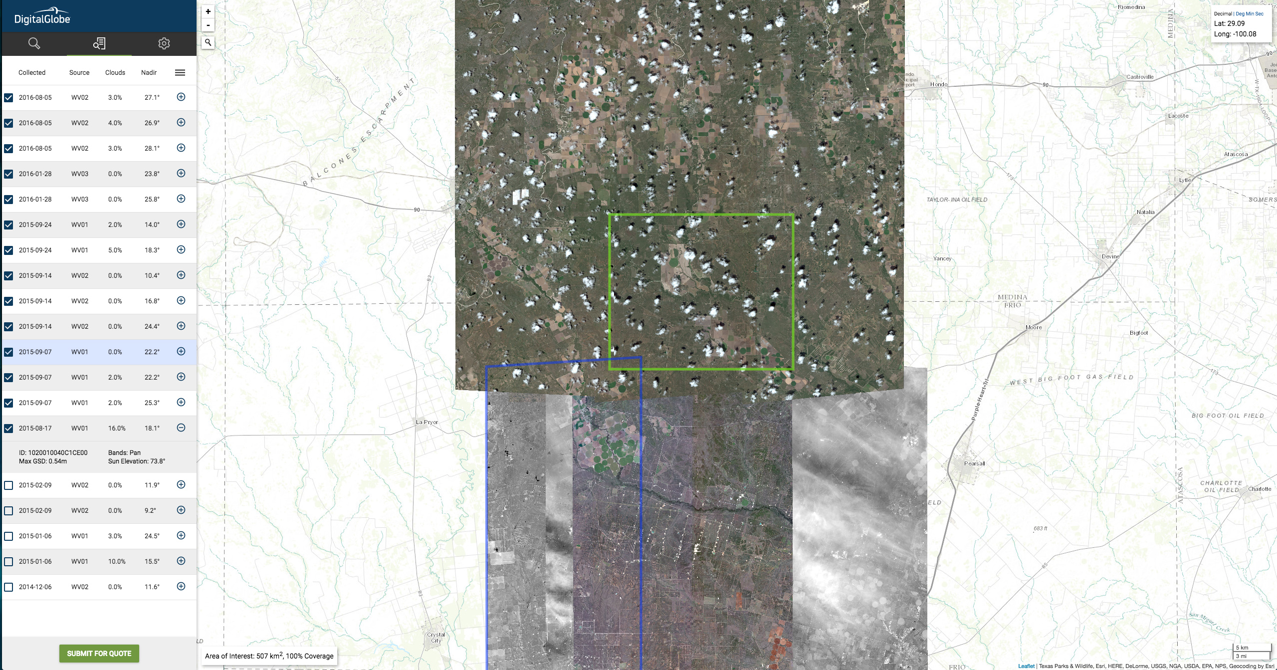 Preview of DigitalGlobe’s image search and discovery tool powered by Esri technology.[/caption]
DigitalGlobe is pleased to explore with you how to find answers to your questions at the Esri European EPUG where we will share more about how the DigitalGlobe Imagery basemap, our 15+ year archive library and GBDX along with Esri tools can be applied to solving the needs of our energy customers.
Preview of DigitalGlobe’s image search and discovery tool powered by Esri technology.[/caption]
DigitalGlobe is pleased to explore with you how to find answers to your questions at the Esri European EPUG where we will share more about how the DigitalGlobe Imagery basemap, our 15+ year archive library and GBDX along with Esri tools can be applied to solving the needs of our energy customers.