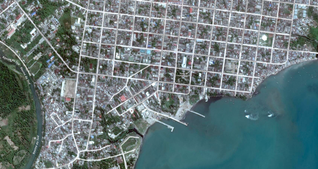
 Les Cayes, Haiti, acquired October 1, 2016 just days before Hurricane Matthew made landfall. Streets ©OpenStreetMap.[/caption]
UPDATE: Crowdsourced data layers from Tomnod of the damage in Haiti are now available on our Open Data Site. That campaign is ongoing, so help us continue to map at http://www.tomnod.com/ These data are also under a CC BY-NC 4.0 license for humanitarian purposes.
Early Tuesday morning, Hurricane Matthew tore through Haiti with 145-mile-per-hour winds and 24-foot waves, leaving a wake of destruction and displacing thousands of families. Sadly, estimates of over 330 casualties are already being reported, and this could rise. First responders and aid agencies are reporting massive flooding in low-lying districts and landslides cutting off entire communities. There are also concerns of another cholera outbreak, as waters are slow to recede.
Many Haitians live in rudimentary shacks crowding the hillsides, and these communities were especially vulnerable to the high winds and torrential rains of the hurricane — as well as the landslides that often occur afterward in rain-loosened soil. Officials are already calling Hurricane Matthew the worst humanitarian event to affect Haiti since the earthquake, and the storm could have overall economic impacts in excess of $10B.
To support the disaster response in-country, DigitalGlobe has been working with Relief and Disaster Response organizations for the past week to make sure they have the latest and best imagery to ensure response decisions can be made with confidence. And today, DigitalGlobe is publicly releasing before and after imagery of the areas impacted, as well as crowdsourced data layers identifying damaged buildings, impassable roads and other sites of major destruction. To ensure these imagery and data can be of most assistance to relief efforts, they will be available under a CC BY-NC 4.0 license for humanitarian purposes. The imagery is also permissible for OpenStreetMap usage.
DigitalGlobe is coordinating with partners like Humanitarian Open Street Map (HOT), the United Nations, American Red Cross and others to disseminate information as quickly and broadly as possible. Please feel free to share this post with your networks to bring awareness to the available imagery and data. DigitalGlobe will continue collecting new images over affected areas throughout the week, as well as monitoring the situation in other affected areas like Cuba, the Bahamas, Florida and along the East Coast.
Les Cayes, Haiti, acquired October 1, 2016 just days before Hurricane Matthew made landfall. Streets ©OpenStreetMap.[/caption]
UPDATE: Crowdsourced data layers from Tomnod of the damage in Haiti are now available on our Open Data Site. That campaign is ongoing, so help us continue to map at http://www.tomnod.com/ These data are also under a CC BY-NC 4.0 license for humanitarian purposes.
Early Tuesday morning, Hurricane Matthew tore through Haiti with 145-mile-per-hour winds and 24-foot waves, leaving a wake of destruction and displacing thousands of families. Sadly, estimates of over 330 casualties are already being reported, and this could rise. First responders and aid agencies are reporting massive flooding in low-lying districts and landslides cutting off entire communities. There are also concerns of another cholera outbreak, as waters are slow to recede.
Many Haitians live in rudimentary shacks crowding the hillsides, and these communities were especially vulnerable to the high winds and torrential rains of the hurricane — as well as the landslides that often occur afterward in rain-loosened soil. Officials are already calling Hurricane Matthew the worst humanitarian event to affect Haiti since the earthquake, and the storm could have overall economic impacts in excess of $10B.
To support the disaster response in-country, DigitalGlobe has been working with Relief and Disaster Response organizations for the past week to make sure they have the latest and best imagery to ensure response decisions can be made with confidence. And today, DigitalGlobe is publicly releasing before and after imagery of the areas impacted, as well as crowdsourced data layers identifying damaged buildings, impassable roads and other sites of major destruction. To ensure these imagery and data can be of most assistance to relief efforts, they will be available under a CC BY-NC 4.0 license for humanitarian purposes. The imagery is also permissible for OpenStreetMap usage.
DigitalGlobe is coordinating with partners like Humanitarian Open Street Map (HOT), the United Nations, American Red Cross and others to disseminate information as quickly and broadly as possible. Please feel free to share this post with your networks to bring awareness to the available imagery and data. DigitalGlobe will continue collecting new images over affected areas throughout the week, as well as monitoring the situation in other affected areas like Cuba, the Bahamas, Florida and along the East Coast.
Some helpful links:
- Open imagery is accessible here: opendata.digitalglobe.com and imagery will continue to be updated throughout the event.
- Crowdsourced data layers from Tomnod of the damage in Haiti are now available on our Open Data Site. That campaign is ongoing, so help us continue to map at http://www.tomnod.com/ These data are also under a CC BY-NC 4.0 license for humanitarian purposes.
- Our imagery will be used in upcoming Humanitarian OpenStreetMap Team (HOT) tasks for Haiti. If you’d like to volunteer time to help map, you can get started here.