This week, the National Oceanic and Atmospheric Administration (NOAA) is celebrating its golden anniversary: 50 years of science, service and stewardship in the name of environmental intelligence. Maxar Technologies admires the way that NOAA has embraced innovation over the last 50 years and is honored to have played a role in the agency’s history.
As a leader in building weather satellites and space infrastructure for more than 60 years, Maxar’s collaboration with NOAA dates back to the first years of the agency. In the mid-1970s, Maxar (then Ford Aerospace) was contracted to build a constellation of three satellites for NASA’s Office of Space Science Applications called Geostationary Operational Environmental Satellite (GOES)-A, -B and -C. These satellites were subsequently handed to NOAA for operation, where they were designated GOES-1, -2 and -3 after their launch on Delta 2914 rockets.

The Delta 2914 rocket that delivered GOES-3 to space. Image: NOAA
The first three GOES satellites led long and storied careers. GOES-3, for example, was originally built for a five-year mission but continued operating for over 38 years, performing a wide variety of weather and communications missions. For a time, GOES-3 even provided internet connectivity for the Amundsen-Scott South Pole Station in Antarctica. The satellite is Maxar’s longest-surviving operational spacecraft and before the end of its mission in 2016 was one of the oldest functioning satellites on orbit.
The Maxar-built GOES-3 satellite spent over thirty-eight years in operation before ending its mission in June 2016. Image: NASA
While the first GOES satellites delivered incredible value over time, they did have some shortfalls. Their primitive spin stabilization required almost no fuel for maintaining satellite orientation, but this design significantly limited the amount of time that the satellites’ sensors were pointed at Earth, creating large gaps in coverage.
In the time between NOAA’s second and third generation of GOES satellites, Maxar was busy building the INSAT-1 series of weather satellites for the Indian Space Research Organization. These satellites provided a revolutionary upgrade over the first GOES satellites by offering three-axis stabilization instead of spin stabilization. By stabilizing over three axes, the INSAT series became the first ever to image continuously as they monitored Earth as opposed to taking an image once every spin, as the prior generation did. This made it possible for weather forecasters to give significantly more accurate and up-to-date weather predictions.
When NOAA began exploring next-generation options for its satellite weather architecture, Maxar was able to offer them this entirely new and innovative solution. This led to Maxar building a series of five more satellites for NOAA, GOES-8 through GOES-12, which launched in the early 2000s. Like their predecessors, GOES 8-12 lasted significantly longer than their original design life of five years, averaging roughly 11 years in operation.

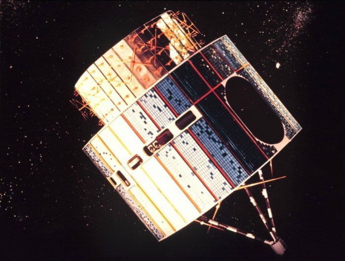
GOES 8-12 were the first-ever NOAA satellites to offer three-axis stabilization for continuous imaging of Earth. Image: NASA
In addition to building eight weather satellites for NOAA, Maxar recently leveraged its expertise in Earth Intelligence to develop an award-winning High Performance compute (HPC) solution using NOAA’s weather forecasting model in the cloud. Maxar’s WeatherDesk team collaborated with Amazon Web Services, Inc. (AWS) to optimize this solution to deliver a detailed global weather forecast 58% faster, reducing a 100-minute process to roughly 42 minutes.
Maxar’s HPC solution delivers forecasts 58% faster, reducing a 100-minute process to roughly 42 minutes.
Now, as NOAA looks towards the next 50 years of innovation and discovery, Maxar is proud to once again support the agency in defining solutions for its next-generation weather mission. In June, NOAA awarded Maxar multiple study contracts to explore potential instruments, spacecraft, business models and mission concepts for its future weather architecture, which will succeed the current GOES satellites.
The agency has asked Maxar to look at both low Earth orbit (LEO) and geostationary orbit (GEO) for this mission. In LEO, Maxar is developing concepts for integrating NOAA weather sensors on its Legion-class platform. In one of the scenarios being considered, Maxar would own and operate the satellites, leveraging the same ground architecture it plans to use for its WorldView Legion high-resolution Earth observation satellites. In GEO, Maxar is examining the use of its 1300-class platform as a dedicated satellite or hosting a NOAA weather payload on another commerical satellite, as it is doing for NASA’s TEMPO pollution monitoring payload.
Maxar is proud of its work with NOAA over the last 50 years and looks forward to continuing to work with the agency. Here’s to 50 more years of science, service and stewardship!
Learn more about Maxar’s next-generation Earth observation and weather solutions.