Recently, Maxar hosted a company-wide mapathon, partnering with the American Red Cross and the Missing Maps Project to create data in OpenStreetMap (OSM). Our mission was to create updated map data in Myanmar before this year’s flood season starts. The American Red Cross and their partners at the Myanmar Red Cross Society (MRCS) will use the updated maps to improve their response time to flooding. Over 120 Maxar employees from around the globe committed their time to add 48,581 new buildings and 1,121 km of roads to the map while more advanced users validated the data.

Following the event, Maxar Analyst Matt Gibb (formerly of the American Red Cross) sat down with Rachel Levine, the Missing Maps Coordinator for the American Red Cross. Below is an edited version of their discussion.
- Matt Gibb: Thanks for joining us!
- Rachel Levine: Thanks for having me!
- MG: For those who didn’t get to participate in our recent volunteer event, what is OSM and why do humanitarian organizations use it?
- RL: OSM is basically the Wikipedia of maps - it’s free, open and editable by anyone. What this means for humanitarian organizations is that we can control our own data!
- MG: How does high-resolution satellite imagery benefit OSM?
- RL: Timely, high-resolution and accurate satellite imagery is extremely important to OSM. Having imagery like Maxar's available allows us to create maps that accurately represent where communities are located on the ground, enabling our in-country teams to work more efficiently. In the context of humanitarian work, we typically need maps of remote areas before and after disasters so we can understand the areas of greatest need and better direct our on-the-ground efforts. These maps are created faster by using Maxar's high-resolution satellite imagery rather than ground-based surveys because people from all over the world can contribute to the mapping process.
- MG: How does the Red Cross utilize geospatial data in their humanitarian efforts?
- RL: Each project is a bit different. Many communities we are working with are literally missing from the map. Basic data like roads, buildings and community names aren’t documented in an accessible way. When decision makers don’t have this information, they can’t make the best choice possible for their community.
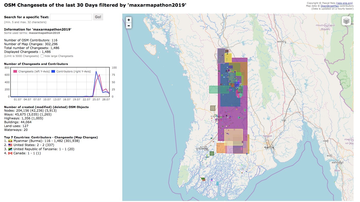
In Myanmar, we mapped large parts of the Ayeyarwady Delta region (see above). This region floods often. We partnered with the Coastal Cities project to document major urban areas that will be affected by sea level rise.
Here is the team in Myanmar to tell you more:
- MG: What is the purpose of a mapathon? How do events like this influence the amount of valid data in OSM?
- RL: Mapathons are events where volunteers add to the map by looking over satellite imagery and tracing features that they see. That way, when we take away the imagery, we are left with a basemap that shows things like roads, buildings, bridges and more. For our more experienced mappers, they can also spend time on quality control or validation.
- RL: Mapathons are events where volunteers add to the map by looking over satellite imagery and tracing features that they see. That way, when we take away the imagery, we are left with a basemap that shows things like roads, buildings, bridges and more. For our more experienced mappers, they can also spend time on quality control or validation.
- MG: Where can people find out more about mapping work being done by the American Red Cross?
- RL: American Red Cross and other Missing Maps member organizations mapping work is highlighted on the Missing Maps blog, with American Red Cross entries on trainings and projects in Belize, Myanmar and Haiti, among others!
- MG: If someone is interested in contributing to OSM, but has no mapping experience, is their volunteering still useful? Where could they find more information and learn how to help?
- RL: YES! We welcome new mappers at our volunteer events and also encourage them to map on their own. There are a number of great resources available for learning how to support OSM responsibly. The Missing Maps website links to a number of different resources from YouTube and LearnOSM, catering to all levels of mappers. The in-browser iD editor on the OSM website also has a great walk-through for new users when they make their first edits.
- MG: How else can users contribute to OSM?
- RL: We all know our own communities best! Check out your neighborhood. If something is missing, add it!
- MG: Any last words you’d like to share?
- RL: To those who participated in last month’s mapping event, thanks so much for your hard work!
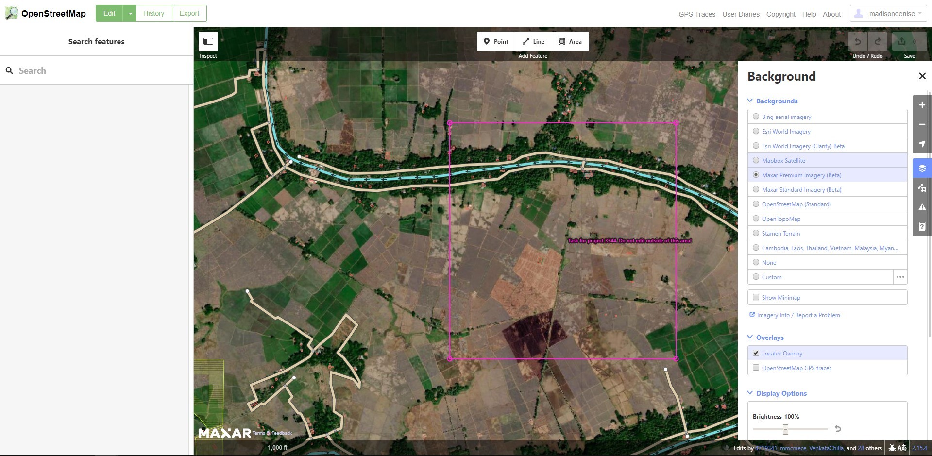
Maxar recognizes that accurate, high-resolution and up-to-date satellite imagery is an essential component for improving this continuously evolving map of our planet – whether it’s to trace new features or to use as a reference layer for validation. Over the years, we have been working with several of our partners to open more data and more imagery to help aid OSM editing. OSM contributors will see two Maxar imagery layers available in the OSM editors – labeled with Beta (as seen in the screenshot above):
- Maxar Premium Imagery (Beta) is a +Vivid mosaic over select regions, 50 cm resolution or better, and refreshed more frequently with ongoing updates.
- Maxar Standard Imagery (Beta) is curated imagery covering 86% of the Earth’s landmass, with 30 cm - 60 cm resolution where available, back-filled by Landsat. Average age of the imagery is 2.31 years, with some areas updated twice yearly.
Maxar has also contributed a number of validation resources to the OSM community, including allowing users to create custom mapping presets with MapRules, as well as integrating validation checks natively into the OSM editing software.
Look for Maxar at State of the Map and State of the Map US. We will be attending and presenting more information on our new imagery service, as well as our validation tools. To learn more about Maxar and our support to the humanitarian community, visit our website.