 This week, Smithsonian’s Air & Space Magazine published a fantastic account of how the U.S. Naval Criminal Investigative Service (NCIS) used commercial satellite imagery to locate Somali pirates who had seized two ships in the Indian Ocean and were holding their crews hostage for ransom. NCIS worked with the Colorado Army National Guard’s 117th Space Battalion, which tasked DigitalGlobe’s WorldView-1 satellite to image roughly 60 square miles of ocean where the Albedo, a 520-foot container ship, and the Naham 3, a 160-foot fishing ship, were suspected to be anchored.
“‘We were lucky to get several clear images free from fog, clouds, and weather, and started looking for anything that could possibly be the target,’ explains team member John Colin.
Colin and Amanda Gibson, another team member, scanned the recent black-and-white images. Three faint white pixels caught Gibson’s eye, and she zoomed in on them. ‘We found the boat!’ Gibson said. The images revealed not only the Albedo but also the Naham 3, tethered with a mooring line to the larger container ship. The team passed the digital image files and geographic information to NCIS.
’It took us just three hours!’ says Colin of the satellite-based search.”
[caption id="attachment_4001" align="aligncenter" width="700"]
This week, Smithsonian’s Air & Space Magazine published a fantastic account of how the U.S. Naval Criminal Investigative Service (NCIS) used commercial satellite imagery to locate Somali pirates who had seized two ships in the Indian Ocean and were holding their crews hostage for ransom. NCIS worked with the Colorado Army National Guard’s 117th Space Battalion, which tasked DigitalGlobe’s WorldView-1 satellite to image roughly 60 square miles of ocean where the Albedo, a 520-foot container ship, and the Naham 3, a 160-foot fishing ship, were suspected to be anchored.
“‘We were lucky to get several clear images free from fog, clouds, and weather, and started looking for anything that could possibly be the target,’ explains team member John Colin.
Colin and Amanda Gibson, another team member, scanned the recent black-and-white images. Three faint white pixels caught Gibson’s eye, and she zoomed in on them. ‘We found the boat!’ Gibson said. The images revealed not only the Albedo but also the Naham 3, tethered with a mooring line to the larger container ship. The team passed the digital image files and geographic information to NCIS.
’It took us just three hours!’ says Colin of the satellite-based search.”
[caption id="attachment_4001" align="aligncenter" width="700"]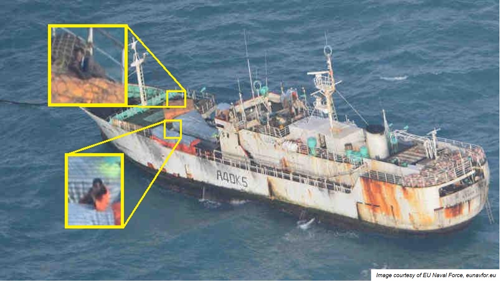 Image captured by an EU Naval Force helicopter in July 2013 confirming that FV Naham 3 remained under the control of pirates. The enlarged images show two armed men on the upper deck. Image courtesy of EU Naval Force.[/caption]
This was great example of how the U.S. Government’s decade-long partnership with DigitalGlobe drives consequence in a truly unique way. But what’s so unique about what DigitalGlobe does? Couldn’t other providers do it faster, better, cheaper? In a word, no.
DigitalGlobe provides U.S. Government users of all kinds access to its entire satellite constellation and imagery archive under a program called EnhancedView, funded by the National Geospatial-Intelligence Agency (NGA). The combination of DigitalGlobe’s technical capabilities, its deep integration with Government systems and workflows, and the structure of the EnhancedView contract result in a valuable public-private partnership that is unique in the industry and would be costly to replicate.
Image captured by an EU Naval Force helicopter in July 2013 confirming that FV Naham 3 remained under the control of pirates. The enlarged images show two armed men on the upper deck. Image courtesy of EU Naval Force.[/caption]
This was great example of how the U.S. Government’s decade-long partnership with DigitalGlobe drives consequence in a truly unique way. But what’s so unique about what DigitalGlobe does? Couldn’t other providers do it faster, better, cheaper? In a word, no.
DigitalGlobe provides U.S. Government users of all kinds access to its entire satellite constellation and imagery archive under a program called EnhancedView, funded by the National Geospatial-Intelligence Agency (NGA). The combination of DigitalGlobe’s technical capabilities, its deep integration with Government systems and workflows, and the structure of the EnhancedView contract result in a valuable public-private partnership that is unique in the industry and would be costly to replicate.
“Let me also say too that we've been in the commercial imagery business for a long time,” NGA Director Robert Cardillo said on Sept. 24 at the Kalaris Intelligence Conference. “I have a mission partner called DigitalGlobe. Essentially I can't do my job today without them. And they're not a start-up, this is a major company providing significant effort to both my mapping, charting and geodesy, and my intelligence mission.”Speed of Delivery Meeting NGA timelines requires a global network of a dozen ground stations, dedicated telecommunications and processing infrastructure, and a highly skilled workforce ready to respond to unpredictable crises. These allow us to collect and produce imagery of more than 60 percent of the earth’s land mass each month, and that imagery is uploaded to our Global EGD web platform as quickly as 12 minutes after downlink. Global EGD has more than 10,000 registered user accounts, reaching an estimated 100,000 users, and integrated with a dozen U.S. Government agency applications. It’s one of many tools that DigitalGlobe uses to bring the benefits of commercial imagery to the U.S. Government workforce at internet speeds. Highest Resolution & Quality DigitalGlobe satellites collect imagery with dramatically higher resolution than any other commercial provider. This very high resolution is essential for U.S. Government missions, from operational planning, to disaster recovery, to situational awareness. Think of it this way: if you can’t tell what you are looking at, it is hard to decide what to do about it: in the example above, this resolution was essential to being able to identify the ships as being the Albedo and the Naham 3. To get this level of resolution from space, you need a large-aperture instrument, and the unbendable rules of physics apply to optics. No advancement in electronics or processing power can make up for the difference in resolution between a large camera and a small one; the “image enhancement” that we see on television crime shows is fantasy, not reality. Resolution is one of several key components of image quality. Equally important for Government missions is accuracy, a measure of how close an object’s position in an image is to its actual location on earth. DigitalGlobe imagery is orders of magnitude more accurate than other commercial satellite imagery. Accuracy matters to safety of navigation. It matters when determining if a potential sniper can see your position. It matters in military operations to avoid collateral damage. It saves lives. Assured Access Not all satellite capacity is created equal. The EnhancedView contract gives the U.S. Government assured—first-in-line—access to the most valuable capacity from DigitalGlobe’s constellation. This enables the U.S. Government to be assured of its ability to monitor critical locations multiple times every day, to have imagery available in support of crisis response when and where it is needed, when seconds or minutes matter. Unclassified, Sharable Information The Air & Space article highlighted another situation in which the six-nation Gulf Cooperation Council needed to search the entire Persian Gulf for oil platforms that were operating illegally. Working with the National Guard unit and NGA, DigitalGlobe tasked a satellite to view each oil platform in the Gulf. The ability to share high-resolution, unclassified imagery with our allies is important, both for joint operations and diplomacy. Security While the imagery itself is unclassified and shareable, DigitalGlobe and the U.S. Government have also made sizeable investments in security infrastructure, allowing commercial imagery to support both the unclassified and classified needs of the U.S. Government. Best Value EnhancedView is not a commodity purchase of imagery at market price. Rather, it is a 10-year, firm-fixed-price contract that runs through 2020. It enables the U.S. Government to enjoy all of the benefits of speed of delivery, quality, first-in-line assured access, shareability and security: a premium service indeed, at far less than the cost of acquiring a similar capability on its own, and at a fraction of market price. Dr. Walter Scott is DigitalGlobe’s Founder and Chief Technology Officer