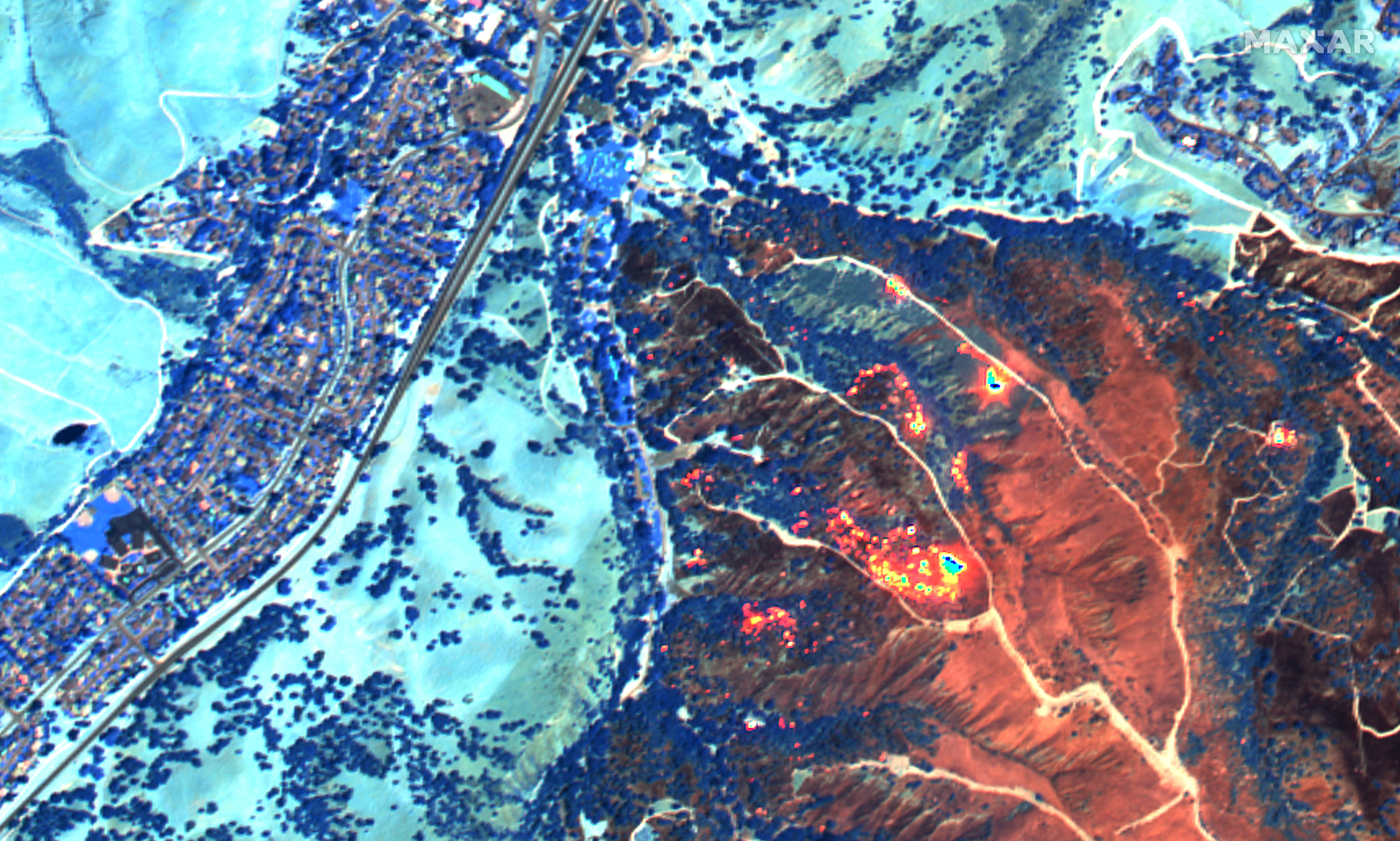
The wildfires ravaging California have caused over a hundred thousand people to evacuate their homes and properties. They are often left waiting in suspense to learn if or how the fire has changed their lives. Maxar’s WorldView-3 satellite has the capability to collect shortwave infrared (SWIR) imagery, which can see through smoke to detect and measure where fires are currently burning and what has already burned.
Maxar and Mapbox, a location data platform for mobile and web applications, have partnered to make our SWIR images over the California wildfires accessible to allow displaced Californians to monitor the homes they had to leave behind. In a SWIR image, active fires and hot spots glow orange and yellow. Burned vegetation appears in shades of dark orange and rust colors. Healthy, unburned vegetation appears in shades of blue. Clouds are still visible in SWIR imagery and typically look like white puffs of cotton.
The slider below compares a SWIR image from August 22, 2020 (during the fire) and a post-fire, August 25, 2020, image of Toro Park, California during the River Fire. You can move the slider back and forth to see how the SWIR image correlates to the burned and unburned parts of the image.
The Maxar SWIR images are available for viewing in the map below1. The map view initially loads the most recent images first; be sure to select past image dates to see if the location you’re interested in was collected previously. There is also a button to view the map using a fullscreen view and a place to type in an address to be taken directly to that location. Maxar will continue to update this map as new SWIR images of the California wildfires are collected.
Additionally, Maxar activated its Open Data Program for these fires to provide the humanitarian and first responder community with actionable information to assist response efforts and fulfill our purpose, For a Better World. Pre-event and during event satellite imagery is available under the Creative Commons Attribution Non-Commercial 4.0 license (CC BY-NC 4.0) for quick integration into first responder workflows. If commercial companies are interested in using the data distributed through the Open Data Program or in this interactive SWIR imagery map, it can be purchased by contacting us here.
These California wildfires have received a Presidential Major Disaster Declaration, enabling state, tribal and local governments to receive federal assistance for emergency response, recovery and protective measures. Due to this declaration, state and local first responders can receive access to Maxar’s satellite imagery of the fires through our Global-Enhanced GEOINT Delivery (Global-EGD) program. To request an account, click the ‘Explore Global-EGD' button on this page.
Mapbox is also offering support to teams building tools for wildfire response and recovery.
Please continue to check this site and our social media channels for updates on additional SWIR imagery and post-event data.
1 Your use of this interactive SWIR imagery map is at your own risk. We provide this map “as is” and “as available”. We do not warrant, and expressly disclaim, that the map and any data or content will be accurate, complete or timely. Actual conditions may differ from the results and content you see on the interactive SWIR imagery map and we are not responsible or liable for such differences.

