Aviation Week recognized Maxar as a 2022 Laureate Award Winner in the Space category for the company’s contributions to sharing data to assist Ukraine and reveal war crimes and human rights violations. The Laureate Awards represent a 65-year tradition of honoring innovators, extraordinary achievements and exemplary leadership in the aerospace, defense and aviation industries.

Maxar’s view from space increases global transparency on Earth
Maxar’s Collection Planning and Mission Operations Center teams balance customer needs to maximize the amount of high-resolution imagery the Maxar constellation can collect. Since February 24, 2022–the day Russia invaded Ukraine–these teams have tasked the constellation to collect more than 3.3 million sq km of imagery over Ukraine.
The Maxar News Bureau aggregates and analyzes thousands of images to identify newsworthy activities happening in Ukraine. The team has produced more than 400 images of the conflict and distributed them to an ever-growing list of journalists and media organizations for dissemination to the general public. Maxar’s industry-leading imagery provides indisputable insight about what is happening on Earth, enabling the public, journalists, customers and governments to more clearly understand the situation and make informed decisions.
From military buildup to full-scale invasion
Maxar has monitored the evolving situation in Ukraine since early 2021, when the News Bureau began releasing images showing the buildup of Russian troops and equipment along the Ukrainian border. At the time, Russia denied having plans to invade Ukraine.

This WorldView-2 image from November 26, 2021, shows a battle group set up near the Pogonovo training area in Russia.

Ground forces and equipment are set up in a camp near Yelnya, Russia, as observed in this GeoEye-1 image from November 9, 2021.

Another deployment camp was established at Novoozernoye, Crimea, Ukraine, as seen in this WorldView-2 image from October 18, 2021.

Tanks, self-propelled artillery and armored vehicles are stationed at Opuk training area in Crimea, Ukraine, as seen in this WorldView-3 image from April 15, 2021.
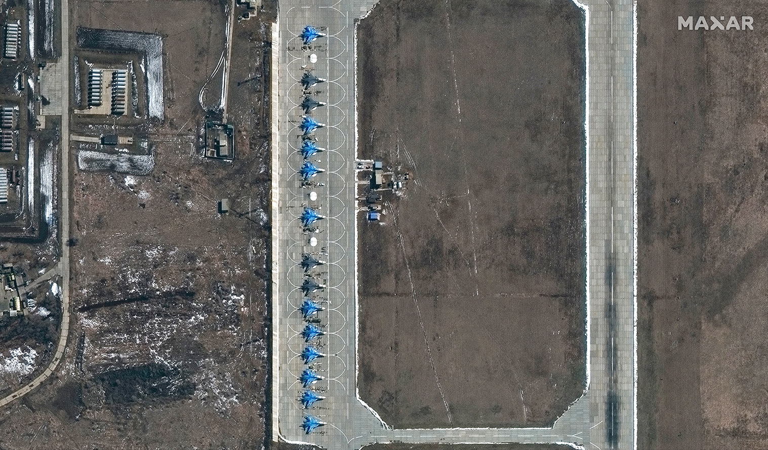
Caption: Russan SU-34 aircraft are parked at Morozovsk Airbase, Russia, on March 27, 2021.
This gallery shows a selection of imagery that revealed Russia’s troop buildup along its border with Ukraine throughout 2021.
The buildup culminated with Russia invading Ukraine on February 24, 2022. Maxar imagery illuminated how the invasion unfolded through publication in media outlets around the globe. In some cases, like the example below, Maxar was the first to provide new information to the world based on what its imagery showed.
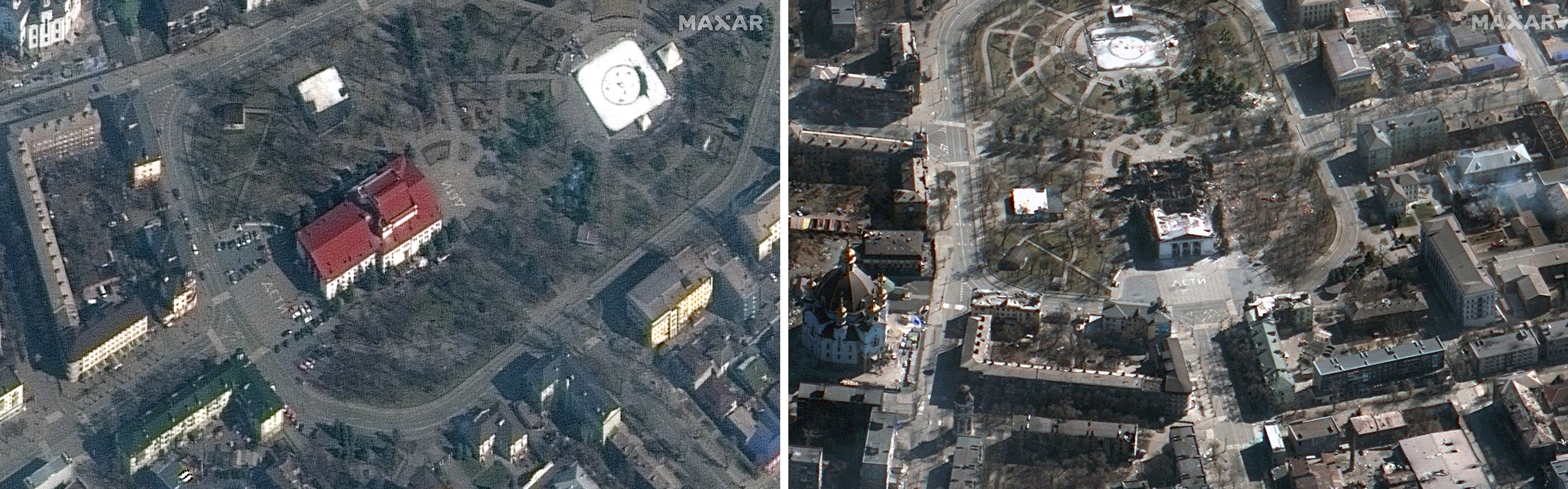
Mariupol citizens painted the word “children” in Russian on the ground outside the city’s theater, where civilians took shelter during Russia’s attack on the city. The left image is from March 14, 2022, before the theater was bombed. The right image from March 19, 2022, shows the destruction of the theater after the March 16, 2022, bombing that killed about 600 people, according to an Associated Press investigation.
Enhanced understanding through additional capabilities
While Maxar imagery provides unique and valuable insight, the Maxar News Bureau has also released information and context provided by additional Maxar capabilities.
Maxar imagery revealed the existence of a 40-mile Russian military convoy that stalled outside Kyiv, Ukraine. Maxar created a 3D video to demonstrate the scope and magnitude of the convoy.
The video, which includes sections of the convoy but not the entire 40-mile length, was created by georegistering WorldView-3 imagery from February 28, 2022, on top of Maxar's Precision3D model of the Kyiv area. This data has an absolute accuracy of 3 meters in all directions, which means objects seen in the video are physically within that 3-meter zone in the real world. This unique view, created with space-based data, offered ground truth when the area was not readily accessible.
This video, created with a Maxar Precision3D model and satellite imagery, shows military vehicles and equipment in a convoy along the road, positioned among tree lines and parked in fields.
Additionally, Maxar’s WeatherDesk team is monitoring Ukraine’s agricultural industry. The country is one of the world’s top three grain exporters and sends its harvests to many parts of the world already facing food insecurity. More disruptions to the distribution of last season’s harvest and this summer’s growing season could further negatively affect global food supplies.
WeatherDesk is an on-demand product that transforms regularly changing weather data into actionable insight. The team has been assessing Ukraine’s 2022 spring crop: farmers planted less acreage this year and will likely harvest up to 50% fewer crops, if the conflict continues with the same intensity.

The map above shows how each Ukrainian oblast’s 2022 spring planting compares to 2021’s growing season. The greatest deficit in planting is represented by dark red, while greater planting than usual is represented by teal.
For A Better World
The months-long effort to release hundreds of images and information about the ongoing conflict in Ukraine is one component of Maxar’s broader effort to harness its capabilities For A Better World. This means improving our technological processes and outputs and connecting visionaries with information, infrastructure and services to make the world a better place.
Maxar will continue to monitor the conflict in Ukraine—and other current events around the world—to increase global transparency and combat the spread of disinformation.
If you are a member of the media interested in receiving Maxar satellite imagery and additional insights, please fill out the News Bureau inquiry form.