Editor’s Note: In a previous post, we explained the difference between the terms ‘weather’ and ‘climate’. This blog will describe the different tools scientists use to observe weather, climate and the environment on Earth.
Weather and climate monitoring is crucial for understanding the current and future state of the atmosphere, allowing us to predict weather patterns and associated hazards, such as floods, hurricanes, wildfires and more. Monitoring is essential to identify and track trends and changes in weather and climate over time. It helps us develop models and projections for future climate conditions, informing business and policy decisions related to climate change mitigation and adaptation.
Accurate monitoring requires combining real-time observations from terrestrial- and space-based sensors like weather stations, atmospheric soundings (radiosondes), drones, aircraft and satellites. Meteorologists and numerical weather prediction (NWP) systems use this data to produce forecasts of current and future weather and climate conditions.
, illustrates the variety of terrestrial- and space-based weather and climate observation sensors.")
The diagram above, from the World Meteorological Organization (WMO), illustrates the variety of terrestrial- and space-based weather and climate observation sensors.
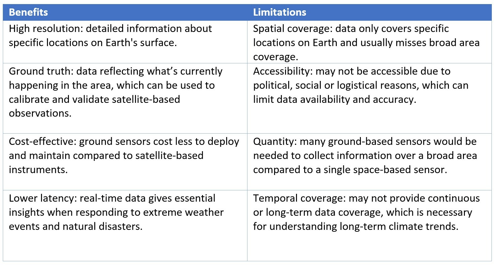
Importance of Terrestrial Observations
Terrestrial-based observation and monitoring sources, typically collected at or just above Earth’s surface, are essential for weather, climate and environmental monitoring but may have limitations in terms of coverage, temporal resolution, accessibility and scalability. High-precision measurements from ground-based weather stations can also be used to calibrate space-based sensors.
TERRESTRIAL-BASED MONITORING
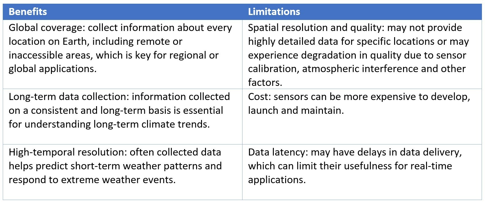
Importance of Space-based Observations
Satellites and other instruments orbiting Earth provide different insights than terrestrial systems even though they both collect data about the planet's atmosphere, oceans and land surface. Satellite-based instruments can complement terrestrial-based sources by providing global coverage, continuous data and scalability. Space instruments include cameras, radar systems and sensors that measure physical properties such as temperature, humidity and surface reflectance. Space-based monitoring offers benefits like global coverage, continuous data, high-temporal resolution and scalability.
SPACE-BASED MONITORING
Maxar’s Earth Intelligence capabilities are built on our industry-leading constellation of electro-optical satellites. These satellites collect the highest resolution commercially available, which enables us to create Digital Terrain Models and Land Use Land Cover maps. These products derived from space monitoring assets enhance NWP models; when Maxar’s Weather and Climate team combines this information with modeling data from NOAA’s National Weather Service (NWS) division and other atmospheric and climate modeling agencies from around the world and our expert insights, it can be used for hazard specific modeling like flooding, wildfire risk and drought, as well as provide critical information for rapid damage assessments.
Maxar is also a leading space manufacturer with a legacy of building weather and climate monitoring instruments. For example, we have collaborated for decades with NOAA to build eight Geostationary Operational Environmental Satellites (GOES), one of the most important weather satellite programs in history. Now, we are helping NOAA determine what its next-generation weather satellites will look like. Through our GeoXO study, engineers are examining how Maxar spacecraft can help NOAA deliver the newest severe weather warning technologies to millions of users, from powerful meteorologist forecasting computers to up-to-the-minute weather apps on your phone. More recently, Maxar arranged for the Intelsat 40e satellite that we were building to host NASA's Tropospheric Emissions: Monitoring of Pollution (TEMPO) instrument for monitoring atmospheric composition. That satellite is currently being commissioned on orbit. Programs like these provide crucial capabilities to monitor and predict weather and atmospheric changes on Earth from space.
Combining monitoring solutions
Observing weather and climate through both types of monitoring provides a more comprehensive understanding of our planet's climate system, helps predict weather patterns, and enables more effective management of natural resources. Together, these methods improve weather forecasting and early warning systems, as well as the accuracy of climate prediction. The fifth-generation European Centre for Medium Range Weather Forecasting (ECMWF) atmospheric reanalysis (ERA-5) is a great example of a dataset that examines past weather and climate, covering the period from January 1940 to present, using data sources from both Earth and space.

This graphic from ECMWF shows how they combine terrestrial- and space-based observations into a comprehensive, global gridded reanalysis dataset of past weather conditions.
Terrestrial- and space-based monitoring technology is always evolving with new advancements in capabilities, data processing and applications. With these developments, humans will be better equipped to predict the weather, manage resources, respond to disasters and address global challenges like climate change. Supporting continued research and investment in these monitoring technologies is crucial for improving our understanding of Earth system and taking action to sustain our planet into the future.
Leverage a full suite of Earth and Space capabilities for your business
Maxar aggregates terrestrial- and space-based weather and climate observations and generates key insights for businesses and governments to use when making decisions.
ClimateDesk can help your organization quantify climate risk and prepare for future conditions. Request a demo.