
The World Wildlife Fund (WWF) and British Antarctic Survey (BAS) have teamed up with Maxar to recruit citizen scientists to assist in conservation efforts of Atlantic and Laptev walrus populations. Walrus from Space, as the project is called, has two phases: identify Maxar satellite images that contain walruses (Phase I) and then count the walruses (Phase II). This process will be repeated each year for five years to track population trends. The resulting survey information will help scientists identify where walruses are spending their time and how walrus habitats and populations are changing during the five-year period in the context of a warming climate, factoring into larger conservation efforts to safeguard the future of walruses and their habitats.
Phase I: Identify walruses in satellite imagery
In 2021, Maxar loaded more than 544,000 high-resolution satellite images from 2020 into a custom version of our crowdsourcing platform called Geospatial Human Imagery Verification Effort (GeoHIVE). In a previous blog post, we described why high-resolution satellite imagery is important for this project.
More than 11,000 citizen scientists examined those Maxar satellite images of Russia, Norway, Greenland and Canada, looking for signs of walruses. GeoHIVE allowed them to examine one image chip at a time, dividing the massive undertaking of reviewing more than 25,000 square kilometers of imagery into manageable tasks. The ability to perform imagery tasking and then review Maxar’s best-in-class, high-resolution satellite imagery is critical for tasks such as wildlife surveys. The subject matter experts (SMEs) determined that 55 image chips had walruses present in them.
In Spring 2022, a new Phase I campaign was launched with 848,343 satellite imagery chips from 2021 for crowd review. So far, 1,121 citizen scientists are working on this phase.
Additionally, in July 2022, WWF and BAS scientists visited a popular walrus location in Norway’s Svalbard Archipelago. During this visit, the scientists collected drone imagery of the walruses at this location. At the same time, Maxar collected new satellite imagery of the area. These complementary datasets will help validate the results of the Walrus from Space campaign.
During each remaining year of the Walrus from Space campaign, Maxar will collect new satellite imagery of these regions for Phase I analysis. When that step is complete, SMEs will validate the results and the images with walruses present will be moved to Phase II analysis.
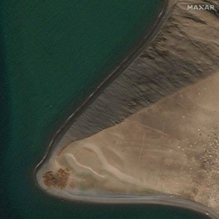
A herd of walruses is visible in the Canadian Arctic in this Maxar WorldView-2 image from August 4, 2020.

In this Maxar WorldView-3 image from July 26, 2020, walruses are seen in Svalbard, a Norwegian archipelago in the Arctic Ocean.

This Maxar WorldView-2 image shows a small group of walruses on July 4, 2021, in Svalbard, a Norwegian archipelago in the Arctic Ocean.
This gallery shows some of the image chips that the crowd identified as having walruses present through Maxar’s GeoHIVE platform’s Walrus from Space campaign.
Phase II: Count walruses
This phase will ask the crowd to count walruses in the 55 image chips from 2020 that were identified by the crowd as having walrus “haul outs,” places on land where walruses gather. GeoHIVE provides two ways to count the walrus: 1) by dropping a point on each walrus if they are distinguishable from each other (i.e., not overlapping), and 2) by drawing a tight polygon around the group of walruses (the scientists have established data allowing them to calculate the number of individuals from the area covered by the group). A citizen scientist can also combine the two methods in a single image chip.
The results from Phase II will be used to track population estimates, changes due to climate change, and to test the efficacy of using citizen scientists to produce accurate data for large-scale conservation problem sets. This new phase of the WWF/BAS Walrus from Space campaign is set to launch January 17, 2023 and will be repeated over the next couple years to monitor changes over time.