Explore how high-resolution and high-accuracy geodata can improve next-generation telecommunications networks planning.
This telecommunications story demonstrates the value of using Maxar’s Precision3D Telco Suite for reliably and precisely planning 5G radio network coverage. Cellular Expert, a leading provider of radio planning software on the ArcGIS platform, performed the analysis used in this simulation and comparison. The results visualize the benefits of using high-resolution geographic information systems (GIS) data to accurately plan telecommunications networks.
Radio planning for previous technologies, like 2G, 3G and 4G, was comparatively “simple” as it did not require detailed predictive analysis for broad area coverage. In contrast, the high capacity 5G systems will initially focus on dense urban areas, and will expand afterwards to the remaining populated areas. They also utilize radio waves in higher frequency bands of 3.5 GHz and above, which are more sensitive to obstacles on the propagation path. This makes 5G radio planning more challenging and requires increased precision to suitably model radio waves diffraction, penetration losses and other negative effects. For this, telecommunications providers will need high-resolution geospatial data, like Maxar’s telco suite at 1 m resolution, to accurately plan the best radio base station (RBS) locations for achieving optimum 5G coverage.
 antennas.")
The icons on this Maxar Vivid imagery basemaps of Milan, Italy, indicate the hypothetical locations of 5G RBS sites used to run this simulated analysis. The simulations modeled a 5G radio network operating in 3.5 GHz and utilizing Multiple-Input Multiple-Output (MIMO) antennas.
Different resolutions, different results:
The new telecommunications technologies have added complexities and require exponentially dense networks to provide service. It has become increasingly difficult for network planners to assure that networks are not over- or under-designed, which can result in higher expenses or longer time to market.
If a telecommunications company opts to use freely available data to plan their networks, one option is the 25 m resolution Advanced Spaceborne Thermal Emission and Reflection Radiometer (ASTER) Digital Elevation Model (DEM) data (in the slider below on the left). This data is less accurate and less descriptive of the environment’s materials than Maxar’s Precision3D Telco Suite (on the below right in 1 m resolution), which can include:
- Digital Terrain Model (DTM), a high-resolution bare earth raster dataset of Earth’s surface without vegetation and man-made structures
- Clutter heights to determine obstacle heights of buildings and vegetation
- Clutter classes that represent multiple, georeferenced elements in raster data, like vegetation, roads and buildings
- 3D vectors for buildings and vegetation
- 4D vectors for bridges
- Orthoimagery that is accurate and high-resolution without parallax or occlusion
Maxar’s data enables the creation of a more precise radio coverage prediction by providing details on features like buildings, vegetation and other structures that are not discernible in the 25 m ASTER DEM data.


Compare the 25 m ASTER DEM data (left) with Maxar’s Precision3D Telco Suite (right).
5G radio simulations comparison between the two datasets:
Comparing the two simulation results clearly shows that Maxar’s geodata enables more precise modeling of radio wave propagation in dense urban conditions. The “street canyons” created by tall buildings cause critical radio waves to be diffracted; lower resolution geodata as a basemap loses those details when planning 5G radio propagation.

This image shows 5G radio coverage planning results displayed in Maxar Precision3D data to illustrate the building obstructions.
Profile view:
The below slider comparison shows the different profile path views, or how the 5G radio signal will travel between the RBS antennas and an end user, between the two datasets. In the lower resolution ASTER DEM data, it appears that the profile path is clear (green line) between the RBS antennas (indicated in blue) and the end user (represented by a pink dot). However, in the higher resolution Maxar data, the obstructions that will affect the radio signal are clearly defined between the RBS antennas and an end user, creating so-called non-line-of-sight conditions that cause disruptions to the received signal. The analysis using Maxar’s Precision3D data shows the high value of having accurate terrain representation by means of DTM, along with the distinct obstacle locations and precise individual heights.
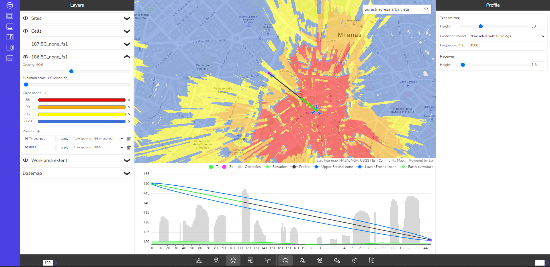
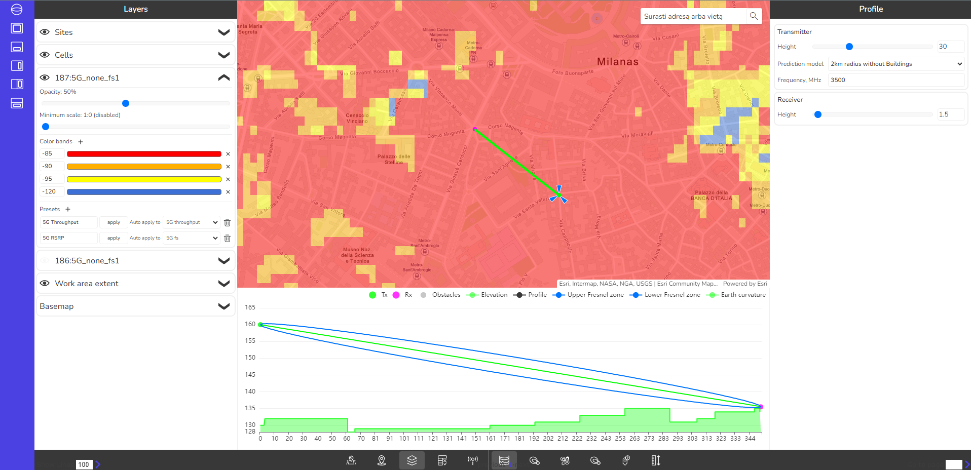
The slider above shows the different radio path profile views for 25 m resolution ASTER DEM geodata (left) and 1 m resolution Maxar's Precision3D Telco Suite (right).
First, in the slider above, note how the use of DEM data as opposed to Maxar’s DTM throws off the precise modeling of the actual height of antennas above the ground level. This is because when a DEM is used, the planning software cannot distinguish between height of clutter and actual ground level. This means antennas may be placed in the model higher above the ground than they actually are in the environment, providing overly confident RSRP results. Conversely, antennas can be placed more accurately in the DTM, enabling better simulations and planning, which saves telecommunications companies time and money when it comes time to deploy the antennas in the environment.
Second, in the slider above, the chart along the bottom shows the necessary radio signal propagation space (called Fresnel zone) along with any disruptions to it, determined from ASTER data (left side, less detailed) and Maxar data (right side, individual buildings outlined).
Designing future 5G radio networks requires the high-accuracy maps that Maxar provides, both in terms of location and building height information.
Why Maxar:
Maxar uses patented imagery processing techniques, as well as big data, artificial intelligence and automation, to generate high-resolution and high-accuracy 3D maps at scale.
This next-generation geodata becomes the centerpiece of network planning, used in conjunction with tuning and propagation software, to create future radio network simulations that are as close to reality as possible.
Read Maxar's white paper about how Precision3D Telco Suite saved a customer capex while deploying a 5G radio network.
Request a demo
Download a sample
About Maxar
Maxar Technologies (NYSE:MAXR) (TSX:MAXR) is a provider of comprehensive space solutions and secure, precise, geospatial intelligence. We deliver disruptive value to government and commercial customers to help them monitor, understand and navigate our changing planet; deliver global broadband communications; and explore and advance the use of space. Our unique approach combines decades of deep mission understanding and a proven commercial and defense foundation to deploy solutions and deliver insights with unrivaled speed, scale and cost effectiveness. Maxar’s 4,400 team members in over 20 global locations are inspired to harness the potential of space to help our customers create a better world. Maxar trades on the New York Stock Exchange and Toronto Stock Exchange as MAXR. For more information, visit www.maxar.com.
About Cellular Expert
Cellular Expert provided the 5G radio propagation analysis using open-source ASTER DEM data and Maxar’s Precision3D Telco Suite.
Cellular Expert is an industry leader in providing continuously innovated, business-oriented ArcGIS-based software tools for network planning, roll-out, and operations management for telecommunications, defense and IoT applications. For more information on their services, visit their website.