Disasters–such as wildfires and hurricanes–are increasingly affecting large areas with spatially dispersed damage. The 2018 Camp Fire in California destroyed more than 18,000 structures, most within a matter of four hours. The Australian Bush Fires in 2019 and 2020 burned 72,000 square miles. As we head into summer and wildfire season here in the United States, response teams are preparing equipment and plans to be ready when their services are needed. Determining where a fire is currently burning, what has already been damaged and the severity of the damage is critical to determining how to deploy response resources. High-resolution satellite imagery covering wide areas plays a key role in providing the foundational data for fire damage assessment reports.
By applying artificial intelligence and machine learning (AI/ML) computer vision algorithms to high-resolution satellite imagery, Maxar helps humanitarian assistance and disaster response (HADR) teams to more quickly and efficiently identify and estimate of the damage caused to buildings and other infrastructure. These advanced AI/ML capabilities are specifically designed for creating damage assessments, which helps focus emergency response efforts on the ground. This is particularly important since affected areas may not be safely accessible by response teams and the extent of other overhead imagery may be limited.
An additional Maxar capability that offers a competitive advantage for wildfire response is the shortwave infrared (SWIR) sensor on WorldView-3, which captures a non-visible range of light through smoke to identify where the fire is burning. We can see the extent of active areas because SWIR light bands are sensitive to thermal emissions that do not register in natural color or NIR imagery. Hot spots, which appear to be cool or non-active in natural color imagery, are easily identified with SWIR because they pop out in the brightest colors, allowing response organizations to know where to send firefighters. Maxar is the only commercial provider of high-resolution SWIR satellite imagery – eight unique bands of light that cannot be seen by the human eye.

WorldView-3 captured images of Paradise, Calif., before the fire (left image) on Sept. 10, 2018 and during the Camp Fire (right image) on Nov. 9, 2018. The SWIR image on the right shows where fire was actively burning during the Camp Fire on Nov. 9, 2018.
Camp Fire damage assessment
Maxar created a damage assessment of Paradise, Calif., after the Camp Fire burned through the town. Using DeepCore, the company’s end-to-end AI/ML pipeline for self-service computer vision analytics, we streamed our high-resolution satellite imagery through Global EGD into a building damage assessment model. This deep learning model uses convolutional neural networks to identify damaged structures in the imagery. This model was trained using previous wildfire imagery released through Maxar’s Open Data Program.
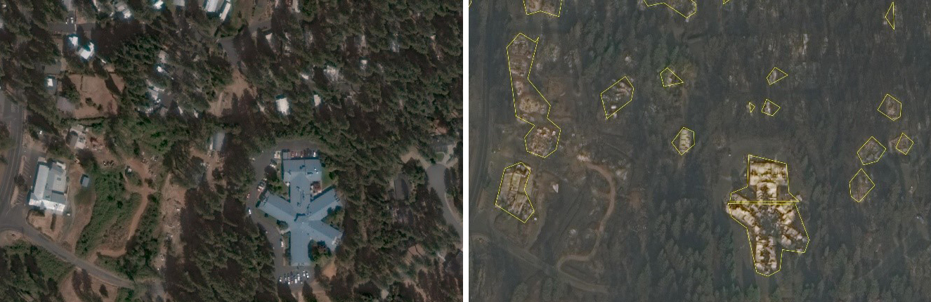
The WorldView-3 image on the left shows Paradise, Calif., before the Camp Fire on September 10, 2018. The image on the right is a WorldView-3 image from after the fire on November 17, 2018. This image also shows the outputs from the DeepCore model indicating destroyed buildings.
Once an instance of our DeepCore AI/ML pipeline was instantiated, the model began identifying buildings and potential damage levels of those buildings across thousands of square kilometers of satellite imagery. The results, which identified hundreds of damaged buildings, can be shared with response teams and combined with other data sources, creating a complete geospatial understanding of how the fire is affecting infrastructure and where resources need to be sent.

These images show low and medium resolution change detection and normalized burn ratio (NBR) data derived from Landsat data. This is an example of third-party data that contributes to a complete geospatial understanding of a wildfire’s impacts.
Applying DeepCore to future wildfires
This combination of using Maxar’s high-resolution satellite imagery and DeepCore can be applied in real-time during future wildfires as soon as new images of the affected area are available.
Maxar will begin launching its new WorldView Legion satellites in early 2021. These six satellites will provide more frequent imagery collections over damaged areas to help track wildfires as they burn.
To learn more about DeepCore’s advanced damage assessment capabilities, please contact us.