As the Imagery Product Manager at Maxar, I have the opportunity to hear firsthand about our customers’ increasing requirements for visual clarity, image sharpness and image consistency to improve their user experience and image analysis workflows. As a result, our team is focused on a continuous improvement strategy to enhance the accuracy and visual quality of our products, and today I am excited to announce the launch of our latest improvement: High-definition (HD) technology.
Maxar has been a leader in the satellite imagery market thanks to our highest resolution and most accurate satellite constellation on orbit. With enhancements like HD, we are able to make our highest-quality imagery products even better. HD technology is a proprietary technique developed and owned by Maxar that improves the visual clarity of an image. The resulting image is refined with precise edges and well-reconstructed details that reduces visual clutter and pixelation that can distract or obstruct interpretation by human eyes and computer vision algorithms alike.
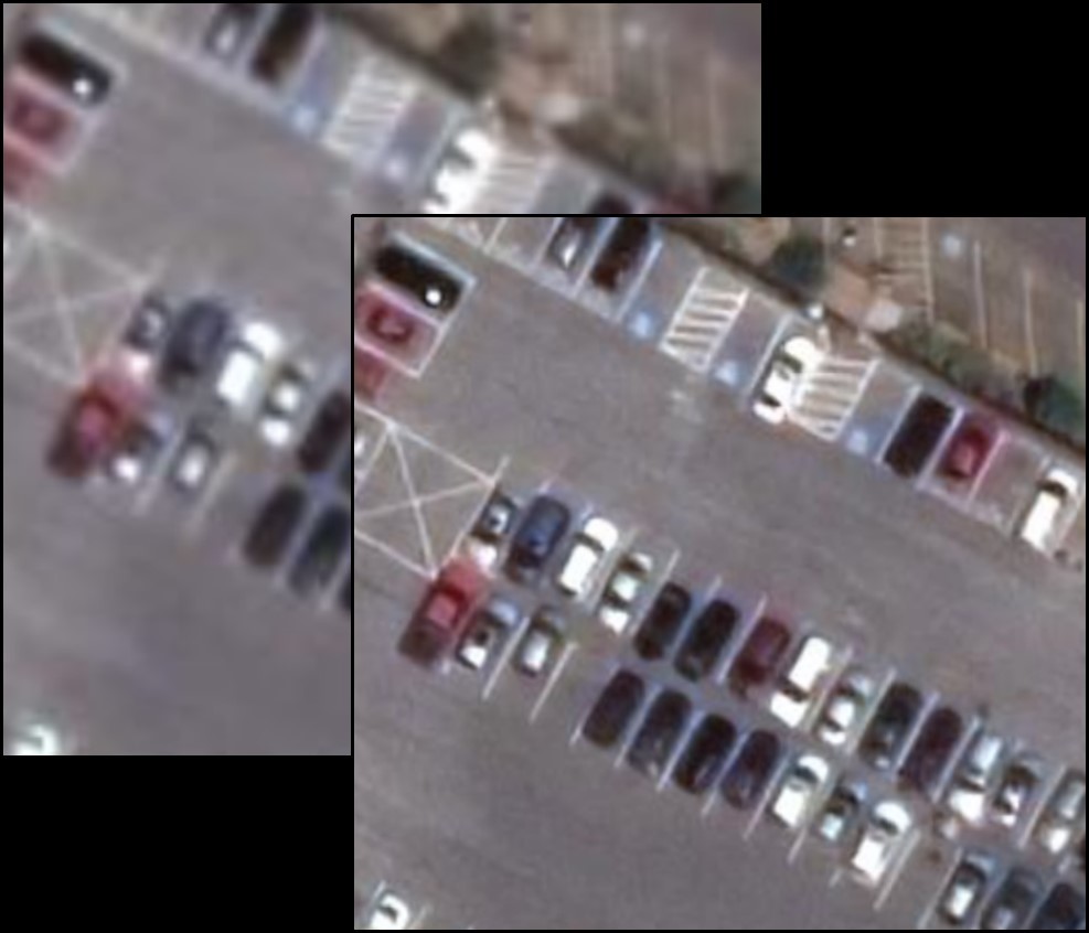
This image was originally collected at 50 cm resolution (left image). After applying HD technology, we now have the 30 cm HD image on the right. The HD image provides enhanced clarity that helps customers identify smaller features and make more informed decisions. 30 cm HD doesn’t replace natively collected 30 cm imagery-it provides more than one way to acquire the quality and utility of 30 cm imagery.
HD is available as an upgrade to our core imagery products (View-Ready and Map-Ready Imagery), our imagery basemaps (Vivid, Metro, and Dynamic) and in SecureWatch.
Unlocking insights to solve critical challenges
When your business decisions require you to identify small features on the ground, an improved visual experience is key. Our HD technology intelligently increases the number of pixels and augments smaller features on the ground. When you can see smaller features more clearly you can do more with Maxar’s imagery and solve more of your business challenges. HD enables you to make better and faster decisions from satellite imagery and saves you money and time on downstream decisions such as reducing field visits required.
The benefits of HD technology
HD can be applied to imagery from the full Maxar constellation, resulting in 30 cm HD images derived from original 50 cm imagery, and an unprecedented 15 cm HD product derived from a native 30 cm image. HD technology delivers:
- Faster project deliveries by leveraging the entire Maxar constellation, providing more than one option to fulfill 30 cm pixel size requirements.
- Increased 30 cm inventory by processing an additional 1.6 million sq km of 50 cm imagery with HD per day
- Better clarity for machine learning algorithms to extract more meaningful information
Applying HD
The below image of Xiadiancun, China was collected at native 30 cm resolution, the highest resolution imagery collected on orbit by a commercial company. Let’s look closely at this image; examine the front of the building and look at the window frames or the metal structure over the front entrance.
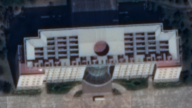
Using the HD technology on this same image, Maxar can now offer a new visual experience by producing a 15 cm HD product (below), which allows you to see smaller details on the front of the building. Compared to the native 30 cm image above, you can tell the HD image below provides better insight into the individual features. For example, features as small as utility covers or power lines can be identified with 15 cm HD.

The two WorldView-3 images are shown in a slider below to make comparing the difference in detail easier.
HD Next Steps
I am very excited to see the launch of HD and help our customers solve more problems with our industry-leading satellite imagery. As we prepare to launch our upcoming WorldView Legion satellites, the value of HD will increase exponentially with the increased availability of 30 cm imagery.
Learn more about HD.