National security missions require the latest information to make critical, time-sensitive decisions that are based in fact. The organizations responsible for ensuring our safety and security must combine a variety of data sources to create a common operating picture of the situation at hand, and high-resolution satellite imagery provides key foundational information for situational awareness. Satellite imagery in general allows for monitoring across the globe, no matter how remote the area of interest or how far from the operations base the AOI is located. But the real value is in the right balance of currency (how recent was the image taken), resolution (the level of detail the image holds), and coverage (the amount of area the satellite collects). By combining the right balance of these criteria, it enables national security organizations to view the whole picture instead of resorting to a “Battleship”-like approach with point-collecting satellites and guessing where activity is happening. With that very current, high-resolution image, analysts understand what's happening anywhere on Earth, identify specific assets on the ground and give end-users unrivaled insights and a competitive edge.
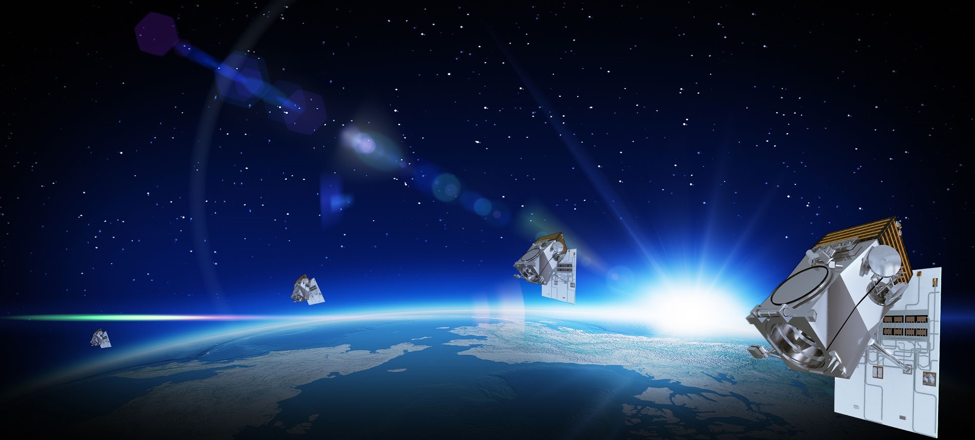
Maxar is manufacturing its next-generation satellite constellation, which will have its first launch early next year. The WorldView Legion constellation (above) will initially include six, high-performance satellites that more than triple Maxar’s capability to collect sub 30 cm resolution imagery, the highest resolution commercially available. This capacity will be a game-changer for our mission partners: they will have dramatically more frequent images (up to 15 times per day) over the most in-demand areas throughout the day for their decision-making processes. This advanced constellation offers high-agility point collects for monitoring targets and large-area collects for mapping missions, enabling more persistent monitoring, near-real time change detection and timely analysis at scale. WorldView Legion will offer Maxar’s mission partners superior Earth Intelligence for their national security missions.
Monitoring for National Security
WorldView Legion will complement our partners’ existing coverage and fill in the important gaps for more persistent surveillance. Consider, for example, the need to verify and validate treaties and enforce sanctions. Currently, Maxar satellites collect images at two different times during the day with a few hours between collections. WorldView Legion will provide coverage from sunup to sundown and reduce the windows between collects, allowing for more persistent monitoring of treaties and sanctions.
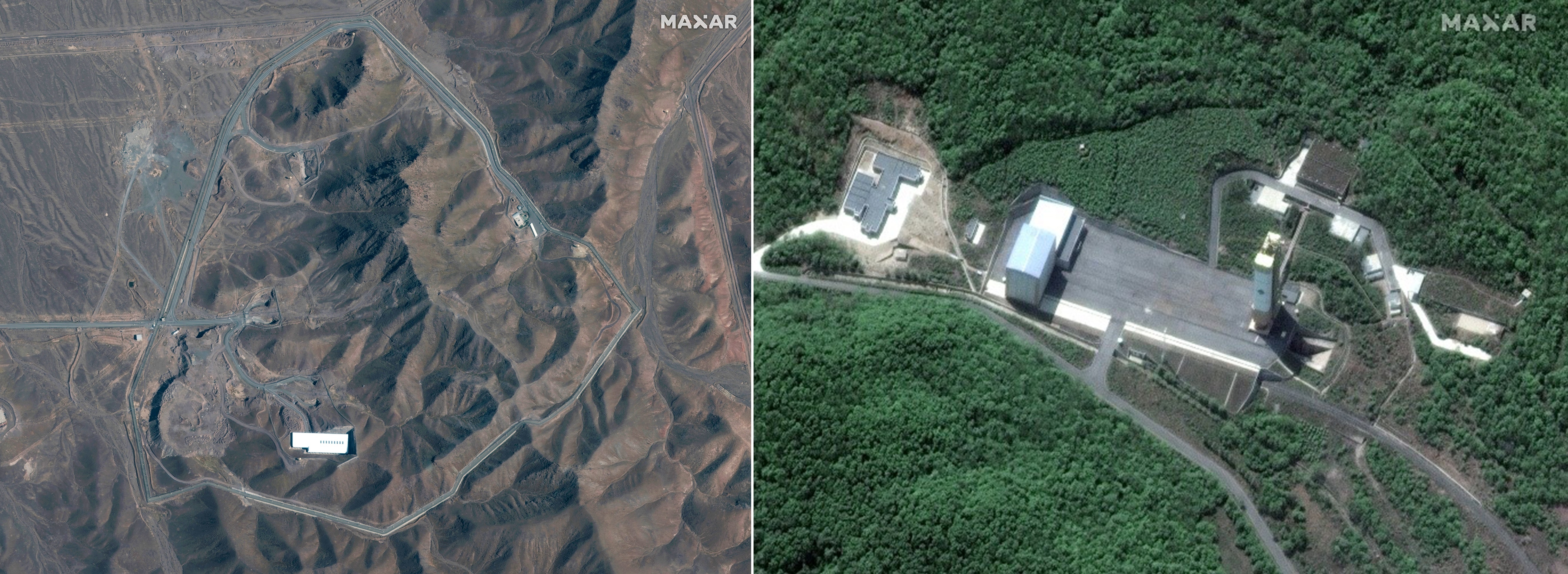
Over the years, Maxar’s WorldView constellation has monitored the development of nuclear and ballistic missile capabilities in North Korea and Iran that have been in violation of international sanctions. These countries are building most of their facilities underground, but Maxar’s satellites capture detailed images of activities on the surface that give analysts insight into the activities there, despite inspectors being prevented from visiting the facilities.
Military mapping for mission support
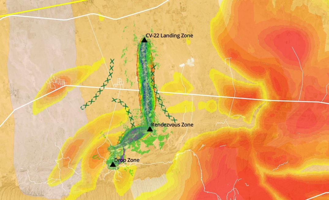
Planning military operations in remote regions or poorly mapped environments presents unique challenges and risks. It is critical that operators and allies have the latest geospatial information including maps and visualization tools, to plan, rehearse and execute missions. The addition of WorldView Legion’s agile satellites and expanded capacity will improve the currency and scale of Maxar’s three-dimensional elevation datasets, mosaics and other mapping products that will help enhance situational awareness and minimize risks and errors in mission planning.
Maritime domain awareness
Nations need to focus their maritime security efforts for challenges such as illegal fishing, pollution, piracy, smuggling, and human and drug trafficking. Maxar Vessel Detection Services (VDS) delivers actionable intelligence for monitoring maritime activities and identifying traffic over broad areas. By leveraging WorldView Legion, coordination across our entire constellation and existing VDS capabilities, Maxar will help maritime agencies address the myriad of challenges in the maritime domain. By helping focus resources through systematically detecting and identifying suspicious maritime activities, Maxar enhances its customers’ ability to evaluate, prioritize and respond faster than ever before.
This video above demonstrates how connecting Maxar's Vessel Detection Service with our electro-optical constellation in a tipping and cueing workflow can enhance maritime domain awareness through dark target detection and identification.
Maxar has decades of experience providing our mission partners with indispensable geospatial intelligence created with cutting-edging technologies. WorldView Legion will shape the next evolution of the type of national security support Maxar provides to its defense and intelligence partners. Learn more about WorldView Legion’s capabilities.
Access to mission-critical GEOINT when and where you need it with Maxar's SecureWatch. Request your evaluation account now.