Note from DigitalGlobe: We are pleased to announce that UNICEF, Development Seed, and Big Pixel Initiative at UC San Diego are our runners-up for the GBDX for Sustainability Challenge. Their solution, “Mapping Schools to Reduce the Digital Divide in Education” is explained in greater detail below. Congratulations to the team for terrific work!
We gave five teams access to our Geospatial Big Data platform (GBDX) and 100 PB imagery library to develop a machine learning solution for one of the United Nations’ Sustainable Development Goals. The teams will have the opportunity to showcase their work at a World Bank-hosted event in Washington, D.C.
There is an increasing number of children who don’t have access to education: it is estimated that by 2030, 60 million children won’t have access to primary education (UNICEF The Estate of the World’s Children 2016). Climate change and global conflicts are only exacerbating this issue by increasing the number of children who are on the move and difficult to reach for education. Without accurate data around schools and their infrastructure, organizations can’t use technology to improve educational opportunities. UNICEF Innovation, UC San Diego’s Big Pixel Initiative, and Development Seed are working together to explore the potential of Convolutional Neural Network (CNN) based algorithms, which take advantage of underlying patterns recognized from very high-resolution satellite imagery to automatically map schools -- mapping the unmapped and making visible the invisible (https://www.projectconnect.world/). Having accurate data about schools is key for organizations to provide quality education, promote lifelong learning (SDG4) ensure equal access to opportunity (SDG10) and eventually, reduce poverty (SDG1). However, this is a challenging task since educational facilities’ records are often inaccurate, incomplete or non-existent. Advances in Earth observation (both in resolution and frequency) and new computational techniques, such as deep learning, bring forth an opportunity to do things that were not possible before. We harnessed this opportunity and we asked the following question: how can we combine very high-resolution satellite imagery and deep learning techniques to map every school in the world? We started our study in rural Liberia and used the very high-resolution (< 1m) satellite imagery from DigitalGlobe to explore different machine learning techniques. Having access to high-resolution imagery was critical for the project since publicly available, low resolution satellite imagery doesn’t provide the sufficient level of detail required to identify individual buildings and characteristics surrounding them (i.e. presence of a playground, material, shape and size of building). Based on the promising results of overall accuracy of +76% and thanks to the computational power of the DigitalGlobe’s GBDX platform and 100 PB imagery archive, we have expanded the CNN-based models to Colombia and tested their transferability to new regions. [caption id="attachment_6398" align="aligncenter" width="602"]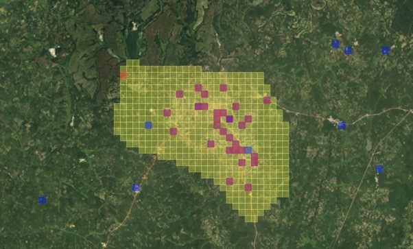 Sample results from Liberia - (1) yellow pixels represent the testing tiles, (2) blue pixels represent school locations, (3) pink pixels represent test tiles predicted as schools that correspond to actual school locations (true positives), (4) orange tiles represent test tiles predicted as schools that don’t correspond to actual school locations (false positives).[/caption]
We believe the GBDX platform has the power to help us scale our models globally and support our mission to provide fair opportunities to every child -- and mapping every school in the world is an important part of this effort. Having this base layer of information will allow us to know what are the connectivity and infrastructure gaps that we need to address in order to improve children’s access to information and education (http://unicefstories.org/magicbox/infopoverty/).
This base layer of information also allows us to explore a range of other applications -- like measuring vulnerabilities and improving our emergency response and resilience against natural disasters and crises. It’s simple enough to describe and broad enough to tackle that it allows us to bring in different partners from different sectors. In fact, we are working with the government of Colombia to explore how we can use this for education in emergencies -- an initial prototype below:
[caption id="attachment_6399" align="aligncenter" width="587"]
Sample results from Liberia - (1) yellow pixels represent the testing tiles, (2) blue pixels represent school locations, (3) pink pixels represent test tiles predicted as schools that correspond to actual school locations (true positives), (4) orange tiles represent test tiles predicted as schools that don’t correspond to actual school locations (false positives).[/caption]
We believe the GBDX platform has the power to help us scale our models globally and support our mission to provide fair opportunities to every child -- and mapping every school in the world is an important part of this effort. Having this base layer of information will allow us to know what are the connectivity and infrastructure gaps that we need to address in order to improve children’s access to information and education (http://unicefstories.org/magicbox/infopoverty/).
This base layer of information also allows us to explore a range of other applications -- like measuring vulnerabilities and improving our emergency response and resilience against natural disasters and crises. It’s simple enough to describe and broad enough to tackle that it allows us to bring in different partners from different sectors. In fact, we are working with the government of Colombia to explore how we can use this for education in emergencies -- an initial prototype below:
[caption id="attachment_6399" align="aligncenter" width="587"] Prototype for the use of school mapping for education in emergencies in Colombia.[/caption]
The results of this project -- including the classification algorithms and analysis based on the data product -- will be shared through our open-source data platform, Magic Box. Magic Box is a collaborative platform, enhanced through contributions from a range of partners that bring their data and expertise for public good -- you can partner with us by providing imagery, data, expertise and other contributions.
We want to thank to DigitalGlobe and AWS for this opportunity -- it has been an invaluable help in taking our work forward in these areas.
Prototype for the use of school mapping for education in emergencies in Colombia.[/caption]
The results of this project -- including the classification algorithms and analysis based on the data product -- will be shared through our open-source data platform, Magic Box. Magic Box is a collaborative platform, enhanced through contributions from a range of partners that bring their data and expertise for public good -- you can partner with us by providing imagery, data, expertise and other contributions.
We want to thank to DigitalGlobe and AWS for this opportunity -- it has been an invaluable help in taking our work forward in these areas.