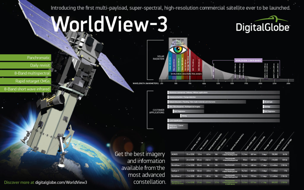
 In 2007, WorldView-1 launched as the first of DigitalGlobe’s next-generation satellites and was considered the most agile imaging satellite ever flown commercially. It can collect more than 1.5 million square kilometers per day of half-meter imagery. In October 2009, WorldView-2 launched and became the first commercial imaging satellite to carry a high resolution 8-band multispectral sensor. It provides the ability to image all of the world’s urban areas every two weeks. It can also image all arable land and permanent crops every month. WorldView-2 opened a number of applications to include mapping wetlands, algae blooms vegetation and urban sprawl, among many. Five years later, WorldView-3 will have double the number of spectral bands, opening even greater capability.
WorldView-3 will be able to provide 31 centimeter resolution from 617 kilometers away. For perspective, that is the same as the distance between Southern California’s Hollywood sign and the Golden Gate Bridge in San Francisco. If the imagery were located at the Hollywood sign, users would be able to count all of the people on the Golden Gate Bridge.
Because the characteristics of various materials reflect light differently, the use of more spectral bands is the key to distinguishing between them and why WorldView-3 will provide panchromatic and 16 spectral bands. This “super-spectral” capability means we’ll be able to see the difference between a red car and a blue car. Very near-infrared enables distinguishing between a Maple tree and a Pine tree. While short-wave infrared provides the ability to “see” through clouds and haze, allowing users to identify houses near a forest fire through the smoke, for example. This is a capability that will be very useful in applications for mapping, land classifications, disaster preparedness and response, soil and vegetation analysis, geology uses, environmental monitoring and coastal applications.
 The satellites in DigitalGlobe’s constellation have steadily evolved with increasing resolution, spectral bands, on-board storage, agility, geolocation accuracy, and downlink rates. Exelis has developed scalable, modular sensor architectures with smaller pixels, faster line rates and better sensitivity enabling improved ground sample distance. All of the improvements made from generation I and II remote sensing satellites have enabled the collection of better data to support decision making across industries.